Difference between revisions of "2013-06-05 49 8"
From Geohashing
imported>Draradech |
imported>QuarterCacher ([live picture] Coordinates reached. [http://www.openstreetmap.org/?lat=49.99757700&lon=8.61264909&zoom=16&layers=B000FTF @49.9976,8.6126]) |
||
| Line 24: | Line 24: | ||
Image:2013-06-05_49_8_restricted.jpg | 500m from the hash, a much stronger restricted area | Image:2013-06-05_49_8_restricted.jpg | 500m from the hash, a much stronger restricted area | ||
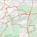
Image:2013-06-05_49_8_track.jpg | Track, round the airport | Image:2013-06-05_49_8_track.jpg | Track, round the airport | ||
| + | |||
| + | Image:2013-06-05_49_8_22-45-37-591.jpg | Coordinates reached. [http://www.openstreetmap.org/?lat=49.99757700&lon=8.61264909&zoom=16&layers=B000FTF @49.9976,8.6126] | ||
</gallery> | </gallery> | ||
Revision as of 20:45, 5 June 2013
| Have you seen our geohashing marker? We'd love to hear from you! Click here to say "hi" and tell us what you've seen!
Curious about what geohashing is? Read more! |  |
| Wed 5 Jun 2013 in 49,8: 49.9976606, 8.6127085 geohashing.info google osm bing/os kml crox |
Location
A very nice spot with different sorts of wild grass and trees. Near Mörfelden-Walldorf.
Participants
Plans
Do a bike hash after work.
Expedition
Did a nice long bike tour (42km) after work and found a very nice hash place. Unfortunately it wasn't reachable, the area is fenced in. So close too, just 11m out.
Photos
Coordinates reached. @49.9976,8.6126
Achievements
Draradech earned the No trespassing consolation prize
|


