Difference between revisions of "2013-06-13 53 -2"
From Geohashing
imported>Angel ([live picture] The OS map looks a bit more promising, though - [http://www.openstreetmap.org/?lat=54.00348837&lon=-2.80574172&zoom=16&layers=B000FTF @54.0035,-2.8057]) |
imported>Angel (Well, there's the bridge. Unfortunately, lots of barbed wire between the path under and the path over [http://www.openstreetmap.org/?lat=54.00170000&lon=-2.80270000&zoom=16&layers=B000FTF @54.0017,-2.8027]) |
||
| Line 44: | Line 44: | ||
Image:2013-06-13_53_-2_10-14-55-634.jpg | The OS map looks a bit more promising, though - [http://www.openstreetmap.org/?lat=54.00348837&lon=-2.80574172&zoom=16&layers=B000FTF @54.0035,-2.8057] | Image:2013-06-13_53_-2_10-14-55-634.jpg | The OS map looks a bit more promising, though - [http://www.openstreetmap.org/?lat=54.00348837&lon=-2.80574172&zoom=16&layers=B000FTF @54.0035,-2.8057] | ||
| + | |||
| + | Image:2013-06-13_53_-2_10-28-09-682.jpg | Well, there's the bridge. Unfortunately, lots of barbed wire between the path under and the path over [http://www.openstreetmap.org/?lat=54.00170000&lon=-2.80270000&zoom=16&layers=B000FTF @54.0017,-2.8027] | ||
</gallery> | </gallery> | ||
Revision as of 09:22, 13 June 2013
| Thu 13 Jun 2013 in 53,-2: 53.9996036, -2.8043952 geohashing.info google osm bing/os kml crox |
Location
Old Park Wood, just off the canal outside Galgate; an easy hour walk from Lancaster (I hope)
Participants
Plans
Expedition
Tracklog
Photos
Looks like this one shouldn't be too hard to get to @54.0213,-2.8084
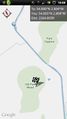
Hmm, not so sure if there's any access from here @54.0041,-2.8067
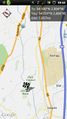
The OS map looks a bit more promising, though - @54.0035,-2.8057
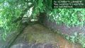
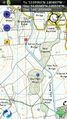
Well, there's the bridge. Unfortunately, lots of barbed wire between the path under and the path over @54.0017,-2.8027


Achievements