Difference between revisions of "2013-06-13 53 -2"
From Geohashing
imported>Angel ([live picture] Hmm, not so sure if there's any access from here [http://www.openstreetmap.org/?lat=54.00411247&lon=-2.80672196&zoom=16&layers=B000FTF @54.0041,-2.8067]) |
imported>FippeBot m (Location) |
||
| (5 intermediate revisions by 3 users not shown) | |||
| Line 23: | Line 23: | ||
<!-- who attended: If you link to your wiki user name in this section, your expedition will be picked up by the various statistics generated for geohashing. You may use three tildes ~ as a shortcut to automatically insert the user signature of the account you are editing with. | <!-- who attended: If you link to your wiki user name in this section, your expedition will be picked up by the various statistics generated for geohashing. You may use three tildes ~ as a shortcut to automatically insert the user signature of the account you are editing with. | ||
--> | --> | ||
| + | * [[User:Angel|Angel]] | ||
== Plans == | == Plans == | ||
| Line 29: | Line 30: | ||
== Expedition == | == Expedition == | ||
<!-- how it all turned out. your narrative goes here. --> | <!-- how it all turned out. your narrative goes here. --> | ||
| + | Presumably no access. <!-- added by Palmpje --> | ||
== Tracklog == | == Tracklog == | ||
| Line 42: | Line 44: | ||
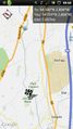
Image:2013-06-13_53_-2_10-13-35-909.jpg | Hmm, not so sure if there's any access from here [http://www.openstreetmap.org/?lat=54.00411247&lon=-2.80672196&zoom=16&layers=B000FTF @54.0041,-2.8067] | Image:2013-06-13_53_-2_10-13-35-909.jpg | Hmm, not so sure if there's any access from here [http://www.openstreetmap.org/?lat=54.00411247&lon=-2.80672196&zoom=16&layers=B000FTF @54.0041,-2.8067] | ||
| + | |||
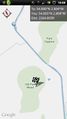
| + | Image:2013-06-13_53_-2_10-14-55-634.jpg | The OS map looks a bit more promising, though - [http://www.openstreetmap.org/?lat=54.00348837&lon=-2.80574172&zoom=16&layers=B000FTF @54.0035,-2.8057] | ||
| + | |||
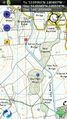
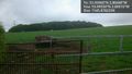
| + | Image:2013-06-13_53_-2_10-28-09-682.jpg | Well, there's the bridge. Unfortunately, lots of barbed wire between the path under and the path over [http://www.openstreetmap.org/?lat=54.00170000&lon=-2.80270000&zoom=16&layers=B000FTF @54.0017,-2.8027] | ||
| + | |||
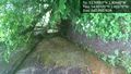
| + | Image:2013-06-13_53_-2_10-48-17-301.jpg | No public access? The hash is in those woods, and the map shows a track across this field; but its not a right of way, so the farmer is quite entitled to have blocked it off. [http://www.openstreetmap.org/?lat=53.99550000&lon=-2.80616000&zoom=16&layers=B000FTF @53.9955,-2.8062] | ||
</gallery> | </gallery> | ||
| Line 48: | Line 56: | ||
<!-- Add any achievement ribbons you earned below, or remove this section --> | <!-- Add any achievement ribbons you earned below, or remove this section --> | ||
| − | |||
| − | |||
| − | |||
| − | |||
| − | |||
| − | |||
| − | |||
| − | |||
| − | |||
| − | |||
| − | |||
[[Category:Expeditions]] | [[Category:Expeditions]] | ||
| − | |||
[[Category:Expeditions with photos]] | [[Category:Expeditions with photos]] | ||
| − | |||
| − | |||
| − | |||
| − | |||
| − | |||
| − | |||
| − | |||
| − | |||
| − | |||
[[Category:Coordinates not reached]] | [[Category:Coordinates not reached]] | ||
| − | |||
| − | |||
| − | |||
| − | |||
| − | |||
[[Category:Not reached - No public access]] | [[Category:Not reached - No public access]] | ||
| − | + | {{location|GB|ENG|LAN}} | |
| − | |||
| − | |||
| − | |||
| − | |||
| − | |||
| − | |||
| − | |||
Latest revision as of 02:49, 14 August 2019
| Thu 13 Jun 2013 in 53,-2: 53.9996036, -2.8043952 geohashing.info google osm bing/os kml crox |
Location
Old Park Wood, just off the canal outside Galgate; an easy hour walk from Lancaster (I hope)
Participants
Plans
Expedition
Presumably no access.
Tracklog
Photos
Looks like this one shouldn't be too hard to get to @54.0213,-2.8084
Hmm, not so sure if there's any access from here @54.0041,-2.8067
The OS map looks a bit more promising, though - @54.0035,-2.8057
Well, there's the bridge. Unfortunately, lots of barbed wire between the path under and the path over @54.0017,-2.8027
No public access? The hash is in those woods, and the map shows a track across this field; but its not a right of way, so the farmer is quite entitled to have blocked it off. @53.9955,-2.8062


