Difference between revisions of "2013-06-16 39 -78"
From Geohashing
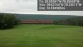
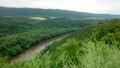
imported>OfficeLinebacker ([live picture] Amazing view [http://www.openstreetmap.org/?lat=39.62240742&lon=-78.25949227&zoom=16&layers=B000FTF @39.6224,-78.2595]) |
imported>OfficeLinebacker ([live picture]) |
||
| Line 50: | Line 50: | ||
Image:2013-06-16_39_-78_14-29-35-333.jpg | Amazing view [http://www.openstreetmap.org/?lat=39.62240742&lon=-78.25949227&zoom=16&layers=B000FTF @39.6224,-78.2595] | Image:2013-06-16_39_-78_14-29-35-333.jpg | Amazing view [http://www.openstreetmap.org/?lat=39.62240742&lon=-78.25949227&zoom=16&layers=B000FTF @39.6224,-78.2595] | ||
| + | |||
| + | Image:2013-06-16_39_-78_14-34-14-531.jpg | | ||
</gallery> | </gallery> | ||
Revision as of 18:34, 16 June 2013
| Sun 16 Jun 2013 in 39,-78: 39.5105090, -78.3556832 geohashing.info google osm bing/os kml crox |
Location
Participants
Plans
Expedition
- Near Berkeley Springs, WV -- OfficeLinebacker (talk) @39.6215,-78.2302 13:12, 16 June 2013 (EDT)
Tracklog
Photos
The Great Cacapon Lodge @39.6216,-78.2301
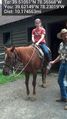
Explaining riding @39.6215,-78.2302
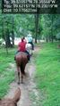
Along for the ride @39.6215,-78.2302

At the Earth Dog cafe @39.6215,-78.2302
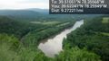
Amazing view @39.6224,-78.2595


Achievements