Difference between revisions of "2013-07-15 33 -117"
From Geohashing
imported>LucasBrown (Local map at hashpoint) |
imported>LucasBrown (→Participants) |
||
| Line 24: | Line 24: | ||
[[User:Mathgeek|Todd Sheaman]] | [[User:Mathgeek|Todd Sheaman]] | ||
| + | |||
| + | [[User:LucasBrown|LucasBrown]] | ||
== Plans == | == Plans == | ||
Revision as of 04:15, 16 July 2013
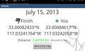
| Mon 15 Jul 2013 in 33,-117: 33.0008243, -117.0324176 geohashing.info google osm bing/os kml crox |
Location
On a power line right of way off Lake Poway Road.
Participants
Plans
No concrete plans yet. Is anyone else interested?
Not too far from home but if I do make it today it will be later in the evening. -Todd
Expedition
Did not attempt Stephen Cerruti (talk) 23:13, 15 July 2013 (EDT)
Tracklog
Photos
Geohash Droid details page at the hashpoint
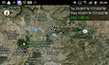
Regional map at hashpoint
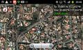
Local map at hashpoint


Achievements