Difference between revisions of "2013-08-04 52 -1"
From Geohashing
imported>Nickholden ([live] Couldn't get into the field, thanks to the hefty padlock on the gate. But the hash point was so close to the hedge that I could get within 3 metres of it while still on the road. Calling that a success.) |
imported>Nickholden (Luckily I didn't need to use the bolt cutters.) |
||
| Line 40: | Line 40: | ||
Image:2013-08-04_52_-1_11-59-44-442.jpg | Just the other side of this hedge. [http://www.openstreetmap.org/?lat=52.58990000&lon=-1.23986000&zoom=16&layers=B000FTF @52.5899,-1.2399] | Image:2013-08-04_52_-1_11-59-44-442.jpg | Just the other side of this hedge. [http://www.openstreetmap.org/?lat=52.58990000&lon=-1.23986000&zoom=16&layers=B000FTF @52.5899,-1.2399] | ||
| + | |||
| + | Image:2013-08-04_52_-1_13-26-43-410.jpg | Luckily I didn't need to use the bolt cutters. | ||
</gallery> | </gallery> | ||
Revision as of 12:26, 4 August 2013
| Sun 4 Aug 2013 in 52,-1: 52.5899243, -1.2398594 geohashing.info google osm bing/os kml crox |
Location
A field off Enderby Road, Thurlaston, Leicestershire, UK.
Participants
Plans
It's only ten kilometres or so from home, and there should be a decent chance at a Tron achievement provided I can navigate the gates around the field itself.
Expedition
- Couldn't get into the field, thanks to the hefty padlock on the gate. But the hash point was so close to the hedge that I could get within 3 metres of it while still on the road. Calling that a success. -- Nickholden (talk) @52.5899,-1.2399 12:03, 4 August 2013 (GMT+01:00)
Tracklog
Photos
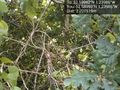
Just the other side of this hedge. @52.5899,-1.2399
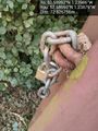
Luckily I didn't need to use the bolt cutters.


Achievements