Difference between revisions of "2013-09-02 40 -86"
From Geohashing
imported>Buttercup |
imported>Buttercup |
||
| Line 33: | Line 33: | ||
== Expedition == | == Expedition == | ||
<!-- how it all turned out. your narrative goes here. --> | <!-- how it all turned out. your narrative goes here. --> | ||
| + | |||
| + | Success! I parked my car on the road that had less traffic. Then I went into the cornfield and walked against the grain until I hit the part where I could walk in between the lines easier. The corn was a bit dry so it was harder to walk through than I thought. | ||
== Photos == | == Photos == | ||
| Line 39: | Line 41: | ||
--> | --> | ||
<gallery perrow="5"> | <gallery perrow="5"> | ||
| − | + | Image:2013-09-02 picture.jpg | Surrounded by corn | |
| + | Image:2013-09-02 40-86gps.png | Success! | ||
</gallery> | </gallery> | ||
| Line 46: | Line 49: | ||
<!-- Add any achievement ribbons you earned below, or remove this section --> | <!-- Add any achievement ribbons you earned below, or remove this section --> | ||
| + | {{land geohash | latitude = 40 | longitude = -86 | date = 2013-09-02 | name = Buttercup | image = 2013-09-02 picture.jpg}} | ||
[[Category:Expeditions]] | [[Category:Expeditions]] | ||
Revision as of 19:27, 2 September 2013
| Mon 2 Sep 2013 in 40,-86: 40.6028551, -86.8134778 geohashing.info google osm bing/os kml crox |
Location
It is in a cornfield near the main road!
Participants
Plans
The plan is to drive and then park on the side of the road. From there I will walk to the hash, hoping no one stops to ask if I am having car trouble!
Expedition
Success! I parked my car on the road that had less traffic. Then I went into the cornfield and walked against the grain until I hit the part where I could walk in between the lines easier. The corn was a bit dry so it was harder to walk through than I thought.
Photos

Surrounded by corn
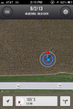
Success!


Achievements
Buttercup earned the Land geohash achievement
|