Difference between revisions of "2013-11-05 52 10"
imported>GeorgDerReisende (new expedition) |
imported>FippeBot m (Location) |
||
| (3 intermediate revisions by 2 users not shown) | |||
| Line 1: | Line 1: | ||
| − | |||
| − | |||
| − | |||
| − | |||
| − | |||
| − | |||
| − | |||
| − | |||
| − | |||
| − | |||
{{meetup graticule | {{meetup graticule | ||
| lat=52 | | lat=52 | ||
| Line 15: | Line 5: | ||
}} | }} | ||
| − | + | ||
__NOTOC__ | __NOTOC__ | ||
== Location == | == Location == | ||
| − | + | ||
| + | The hash lies on the street Berger Weg in Hermannsburg, county Celle. | ||
== Participants == | == Participants == | ||
| − | + | ||
| − | + | * [[User:GeorgDerReisende|GeorgDerReisende]] | |
== Plans == | == Plans == | ||
| − | + | ||
| + | Hitchhike there, dance around, hitchhike home. | ||
== Expedition == | == Expedition == | ||
| − | + | ||
| + | I failed again. I started at home at 10:30, started hitchhiking at 11:30 and got a car to the service station Göttingen after 20 minutes. But at the service station I waited for two hours and nothing happended. There could have been some unusual reasons, the two I have seen, had been the empty parking area for the trucks and the small amount of cars on the motorway. Also the cars all drived slowly. So - no cars, no lifts. Then I gave up and tried to hitchhike to Göttingen, but there was no luck, too. So I walked to Rosdorf, passed the site of [[2013-08-15 51 9]] and took a bus, at first to the city, then to the motorway. In the afternoon the traffic was normal and I got a lift to Kassel within ten minutes. | ||
== Tracklog == | == Tracklog == | ||
| Line 34: | Line 27: | ||
== Photos == | == Photos == | ||
| − | + | ||
| − | |||
| − | |||
<gallery perrow="5"> | <gallery perrow="5"> | ||
| + | Image:2013-11-05 52 10 GeorgDerReisende 2803.jpg | The empty service station | ||
| + | Image:2013-11-05 52 10 GeorgDerReisende 2812.jpg | View to the [[2013-08-15 51 9]] area | ||
| + | Image:2013-11-05 52 10 GeorgDerReisende 2816.jpg | The autumn near Göttingen | ||
</gallery> | </gallery> | ||
| Line 45: | Line 39: | ||
| − | |||
| − | |||
| − | |||
| − | |||
| − | |||
| − | |||
| − | |||
| − | |||
| − | |||
| − | |||
[[Category:Expeditions]] | [[Category:Expeditions]] | ||
| − | |||
[[Category:Expeditions with photos]] | [[Category:Expeditions with photos]] | ||
| − | |||
| − | |||
| − | |||
| − | |||
| − | |||
| − | |||
| − | |||
| − | |||
[[Category:Coordinates not reached]] | [[Category:Coordinates not reached]] | ||
| − | |||
| − | |||
| − | |||
| − | |||
| − | |||
| − | |||
| − | |||
| − | |||
[[Category:Not reached - Technology]] | [[Category:Not reached - Technology]] | ||
| − | + | {{location|DE|NI|CE}} | |
| − | |||
| − | |||
| − | |||
| − | |||
Latest revision as of 04:34, 14 August 2019
| Tue 5 Nov 2013 in 52,10: 52.8442294, 10.0668707 geohashing.info google osm bing/os kml crox |
Location
The hash lies on the street Berger Weg in Hermannsburg, county Celle.
Participants
Plans
Hitchhike there, dance around, hitchhike home.
Expedition
I failed again. I started at home at 10:30, started hitchhiking at 11:30 and got a car to the service station Göttingen after 20 minutes. But at the service station I waited for two hours and nothing happended. There could have been some unusual reasons, the two I have seen, had been the empty parking area for the trucks and the small amount of cars on the motorway. Also the cars all drived slowly. So - no cars, no lifts. Then I gave up and tried to hitchhike to Göttingen, but there was no luck, too. So I walked to Rosdorf, passed the site of 2013-08-15 51 9 and took a bus, at first to the city, then to the motorway. In the afternoon the traffic was normal and I got a lift to Kassel within ten minutes.
Tracklog
Photos
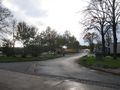
The empty service station
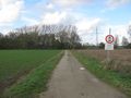
View to the 2013-08-15 51 9 area
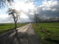
The autumn near Göttingen


