Difference between revisions of "2013-11-23 52 9"
imported>GeorgDerReisende (new expedition) |
imported>FippeBot m (Location) |
||
| (3 intermediate revisions by one other user not shown) | |||
| Line 1: | Line 1: | ||
| − | |||
| − | |||
| − | |||
| − | |||
| − | |||
| − | |||
| − | |||
| − | |||
| − | |||
| − | |||
{{meetup graticule | {{meetup graticule | ||
| lat=52 | | lat=52 | ||
| Line 18: | Line 8: | ||
__NOTOC__ | __NOTOC__ | ||
== Location == | == Location == | ||
| − | + | ||
| + | The hash lies on the property Freihorstfeld 50 in Hannover. | ||
== Participants == | == Participants == | ||
| − | + | ||
| − | + | [[User:GeorgDerReisende|GeorgDerReisende]] | |
== Plans == | == Plans == | ||
| − | + | ||
| + | To hitchhike to Hannover, looking around, meet other geohashers at 16:00, hitchhike home. The site seems to be a public children's playground, but the view at google's street view shows a fence with a gate. | ||
== Expedition == | == Expedition == | ||
| − | + | ||
| + | I left home at 10:00, waited for a lift from 10:57 to 11:17, waited another five minutes at the service station Göttingen and arrived at Hannover at 12:54. I walked a little bit around, then I walked to the hash. I arrived there at about 16:00, but I found the gate closed. Then I noticed, that I had forgotten to program my Garmin and I didn't know the exact location, but because I couldn't go onto the place, there was no more harm. | ||
== Tracklog == | == Tracklog == | ||
| − | + | ||
== Photos == | == Photos == | ||
| Line 38: | Line 31: | ||
--> | --> | ||
<gallery perrow="5"> | <gallery perrow="5"> | ||
| + | Image:2013-11-23 52 9 GeorgDerReisende 3585.jpg | the hash is near | ||
| + | Image:2013-11-23 52 9 GeorgDerReisende 3586.jpg | the gate is closed | ||
| + | Image:2013-11-23 52 9 GeorgDerReisende 3587.jpg | | ||
| + | Image:2013-11-23 52 9 GeorgDerReisende 3594.jpg | view to the place | ||
| + | Image:2013-11-23 52 9 GeorgDerReisende 3595.jpg | | ||
| + | Image:2013-11-23 52 9 GeorgDerReisende 3597.jpg | proof1 | ||
| + | Image:2013-11-23 52 9 GeorgDerReisende 3598.jpg | proof2 | ||
| + | Image:2013-11-23 52 9 GeorgDerReisende 3625.jpg | proof3 | ||
</gallery> | </gallery> | ||
| Line 45: | Line 46: | ||
| − | + | [[Category:Expeditions]] | |
| − | |||
| − | [[Category: | ||
| − | |||
| − | |||
| − | |||
| − | |||
| − | |||
| − | |||
| − | |||
| − | |||
[[Category:Expeditions with photos]] | [[Category:Expeditions with photos]] | ||
| − | |||
| − | |||
| − | |||
| − | |||
| − | |||
| − | |||
| + | [[Category:Coordinates not reached]] | ||
| − | |||
| − | |||
| − | |||
| − | |||
| − | |||
| − | |||
| − | |||
[[Category:Not reached - No public access]] | [[Category:Not reached - No public access]] | ||
| − | + | {{location|DE|NI|H}} | |
| − | |||
| − | |||
| − | |||
| − | |||
| − | |||
| − | |||
| − | |||
Latest revision as of 04:44, 14 August 2019
| Sat 23 Nov 2013 in 52,9: 52.3583122, 9.8103295 geohashing.info google osm bing/os kml crox |
Location
The hash lies on the property Freihorstfeld 50 in Hannover.
Participants
Plans
To hitchhike to Hannover, looking around, meet other geohashers at 16:00, hitchhike home. The site seems to be a public children's playground, but the view at google's street view shows a fence with a gate.
Expedition
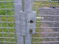
I left home at 10:00, waited for a lift from 10:57 to 11:17, waited another five minutes at the service station Göttingen and arrived at Hannover at 12:54. I walked a little bit around, then I walked to the hash. I arrived there at about 16:00, but I found the gate closed. Then I noticed, that I had forgotten to program my Garmin and I didn't know the exact location, but because I couldn't go onto the place, there was no more harm.
Tracklog
Photos
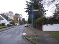
the hash is near
the gate is closed
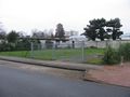
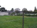
view to the place
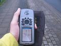
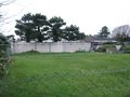
proof1
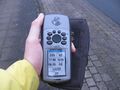
proof2
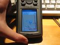
proof3


