Difference between revisions of "2013-11-30 global"
imported>Far (Added description, and some templating) |
imported>Far (Added meetup template) |
||
| Line 1: | Line 1: | ||
This is a temporary page / image placeholder for 2013-11-30 Globalhash. | This is a temporary page / image placeholder for 2013-11-30 Globalhash. | ||
| + | {{meetup global|date=2013-11-30}} | ||
| + | __NOTOC__ | ||
== Location == | == Location == | ||
On the lake in the middle of suburban area. | On the lake in the middle of suburban area. | ||
| Line 10: | Line 12: | ||
== Expedition == | == Expedition == | ||
| − | I got the news of this handy set of coordinates by [[User:Rex Wolf|Rex Wolf]], who begged and pleaded me to go and grab it. Sure, why not, I thought, and started digging in for more information about it. When at first I couldn't match the location for any hashes for the date, I started wondering what's wrong with this... and then I figured it out. It's a Globalhash, not your every day Geohash! Of course I'll go get it! And it couldn't be more conveniently placed anyway, since it was | + | I got the news of this handy set of coordinates by [[User:Rex Wolf|Rex Wolf]], who begged and pleaded me to go and grab it. Sure, why not, I thought, and started digging in for more information about it. When at first I couldn't match the location for any hashes for the date, I started wondering what's wrong with this... and then I figured it out. It's a Globalhash, not your every day Geohash! Of course I'll go get it! And it couldn't be more conveniently placed anyway, since it was within 5 kilometer radius from my home. What a brilliant start for my geohashing career! |
| − | It was apparent that the coordinates were on the lake, and since we're still early in the winter, I doubted I could sneak close enough to get a proper grab of it. But since these things don't pop up every day in the | + | It was apparent that the coordinates were on the lake, and since we're still early in the winter, I doubted I could sneak close enough to get a proper grab of it. But since these things don't pop up every day in the neighbourhood, I figured getting within line of sight is good enough for me. |
I started early, since the weather was getting gradually worse toward midday. I didn't quite escape the snow, but it wasn't too bad, just a mildly slippery drive to a nearby parking lot. The little forest area towards the hash point was littered with pathways, so it was a quick walk there. | I started early, since the weather was getting gradually worse toward midday. I didn't quite escape the snow, but it wasn't too bad, just a mildly slippery drive to a nearby parking lot. The little forest area towards the hash point was littered with pathways, so it was a quick walk there. | ||
| Line 18: | Line 20: | ||
It became quickly apparent that getting on the ice was definitely a no-go. Water around the trees along the shoreline hadn't frozen yet, so I couldn't really trust the ice any better, not with my usual weight-to-surface-area ratio. A little kick on the ice was pushing water up, so I decided to admire this magical location afar. | It became quickly apparent that getting on the ice was definitely a no-go. Water around the trees along the shoreline hadn't frozen yet, so I couldn't really trust the ice any better, not with my usual weight-to-surface-area ratio. A little kick on the ice was pushing water up, so I decided to admire this magical location afar. | ||
| − | I quickly gathered some data from my locating devices (touchscreens get silly when wet), TomTom One (3rd ed.) was getting a decent view of satellites, and my Sony-Ericsson was getting some numbers as well. But in the end, GPS software said I was off about 45 meters, and little Excel magic back home confirms that the closest I got was about 40 meters east of the spot. | + | I quickly gathered some data from my locating devices (touchscreens get silly when wet), TomTom One (3rd ed.) was getting a decent view of satellites, and my Sony-Ericsson was getting some numbers as well. But in the end, GPS software said I was off about 45 meters, and little Excel magic back at home confirms that the closest I got was about 40 meters east of the spot. |
| − | Interestingly, I noticed something on the ice about where the true location would be. Maybe some daredevil had gotten there before me? Or nature had provided a handy little marker in advance? | + | Interestingly, I noticed something on the ice about where the true location would be. Maybe some daredevil had gotten there before me? Or nature had provided a handy little marker in advance, how does she know? |
| − | I grabbed a couple of pictures for panoramas to stitch back at home, looked around | + | I grabbed a couple of pictures for panoramas to stitch back at home, looked around in hopes of hordes of excited geohashers to arrive, and sneaked back to my car in the increasing snowfall. Close, but no cigar. |
== Photos == | == Photos == | ||
Revision as of 13:21, 30 November 2013
This is a temporary page / image placeholder for 2013-11-30 Globalhash.
|
Globalhash on Sat 30 Nov 2013: |
Location
On the lake in the middle of suburban area.
Participants
Expedition
I got the news of this handy set of coordinates by Rex Wolf, who begged and pleaded me to go and grab it. Sure, why not, I thought, and started digging in for more information about it. When at first I couldn't match the location for any hashes for the date, I started wondering what's wrong with this... and then I figured it out. It's a Globalhash, not your every day Geohash! Of course I'll go get it! And it couldn't be more conveniently placed anyway, since it was within 5 kilometer radius from my home. What a brilliant start for my geohashing career!
It was apparent that the coordinates were on the lake, and since we're still early in the winter, I doubted I could sneak close enough to get a proper grab of it. But since these things don't pop up every day in the neighbourhood, I figured getting within line of sight is good enough for me.
I started early, since the weather was getting gradually worse toward midday. I didn't quite escape the snow, but it wasn't too bad, just a mildly slippery drive to a nearby parking lot. The little forest area towards the hash point was littered with pathways, so it was a quick walk there.
It became quickly apparent that getting on the ice was definitely a no-go. Water around the trees along the shoreline hadn't frozen yet, so I couldn't really trust the ice any better, not with my usual weight-to-surface-area ratio. A little kick on the ice was pushing water up, so I decided to admire this magical location afar.
I quickly gathered some data from my locating devices (touchscreens get silly when wet), TomTom One (3rd ed.) was getting a decent view of satellites, and my Sony-Ericsson was getting some numbers as well. But in the end, GPS software said I was off about 45 meters, and little Excel magic back at home confirms that the closest I got was about 40 meters east of the spot.
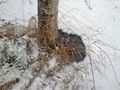
Interestingly, I noticed something on the ice about where the true location would be. Maybe some daredevil had gotten there before me? Or nature had provided a handy little marker in advance, how does she know?
I grabbed a couple of pictures for panoramas to stitch back at home, looked around in hopes of hordes of excited geohashers to arrive, and sneaked back to my car in the increasing snowfall. Close, but no cigar.
Photos
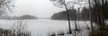
Arrived on site, snowing wasn't too bad yet.
Checked the ice, I'm not going there!
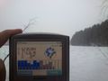
Started checking my devices, good old Tomtom...
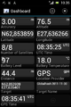
... and GPS Essentials for my tinyphone.
Yeah, it's out there. And something else too...
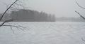
Looks like there's something out there on the ice. Marker? Wood? Early Geohashing bird?

Yeah, no Stupid Grin tm , I was getting snowflakes stuck in me teef.

Wider shot of the area.
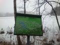
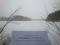
Also, signs were most helpful.


