Difference between revisions of "2013-12-14 46 -122"
imported>Rex Wolf (Created expedition page) |
imported>FippeBot m (Location) |
||
| (3 intermediate revisions by one other user not shown) | |||
| Line 13: | Line 13: | ||
| lon=-122 | | lon=-122 | ||
| date=2013-12-14 | | date=2013-12-14 | ||
| + | | graticule_name=Mount St. Helens | ||
| + | | graticule_link=Mt. St. Helens, Washington | ||
}} | }} | ||
| Line 19: | Line 21: | ||
== Location == | == Location == | ||
<!-- where you've surveyed the hash to be --> | <!-- where you've surveyed the hash to be --> | ||
| + | In a field just south of the Lewis-McChord Air Force Base. | ||
== Participants == | == Participants == | ||
<!-- who attended: If you link to your wiki user name in this section, your expedition will be picked up by the various statistics generated for geohashing. You may use three tildes ~ as a shortcut to automatically insert the user signature of the account you are editing with. | <!-- who attended: If you link to your wiki user name in this section, your expedition will be picked up by the various statistics generated for geohashing. You may use three tildes ~ as a shortcut to automatically insert the user signature of the account you are editing with. | ||
--> | --> | ||
| + | * [[User:Rex Wolf|Rex Wolf]] ([[User talk:Rex Wolf|talk]]) | ||
== Plans == | == Plans == | ||
<!-- what were the original plans --> | <!-- what were the original plans --> | ||
| + | I had some extra time to kill, the hash looked fun, and it was within drivable range. Spontaneity! | ||
== Expedition == | == Expedition == | ||
<!-- how it all turned out. your narrative goes here. --> | <!-- how it all turned out. your narrative goes here. --> | ||
| + | Driving down to the area of the hash itself was interesting. With my recent work-sponsored phone upgrade, I didn't have any capability for US data yet. I took some time to familiarize myself with the roads in the area before I left, but then I was totally on my own. No data, no maps. Just memory! | ||
| + | |||
| + | Of course, I had to go through Lewis-McChord Air Force Base to get to the right area. Or at least, I went through on a main road that cuts through the southern portion of the base. I did see at least one of the big Chinook heavy-lift helicopters flying overhead, but it was gone in the trees before I could get a picture of it. | ||
| + | |||
| + | The roads towards the hashpoint seemed an awful lot like driveways over flat land, heading for the ridge where the trees and houses were perched. I followed one until I couldn't follow it any more. I could have gone further, but the road was dug up in a trench, with a line running through it. I guessed they were doing some maintenance and just parked the car there. | ||
| + | |||
| + | Walking forward a bit, I came to a fenced area with a gaggle of chickens staring at me. I took a photo, chuckling at them, before stumping onwards. A few seconds later, there was a commotion, and I turned to see the chickens coming after me in hot pursuit! Still on their side of the fence, but I thought it was really funny. | ||
| + | |||
| + | As I went, I noticed that Mt. Ranier was looking very beautiful out to the northwest, so I detoured slightly so as to take a good shot of that. Turning back to the hashpoint, I soon found my way blocked by a fence. There were more fences out in the field, and I guessed the hashpoint wasn't just in a field, but a cattle field. | ||
| + | |||
| + | Retreating back to my car, I belatedly noticed a sign leaning up against a tree, opposite from the chicken run. Um... oops! Sorry... | ||
== Tracklog == | == Tracklog == | ||
<!-- if your GPS device keeps a log, you may post a link here --> | <!-- if your GPS device keeps a log, you may post a link here --> | ||
| + | [[:Image:Rex-MtStHelens-2013-12-14-tracklog.png|Rex's tracklog as PNG.]] | ||
== Photos == | == Photos == | ||
| Line 38: | Line 55: | ||
--> | --> | ||
<gallery perrow="5"> | <gallery perrow="5"> | ||
| + | Image:Rex-MtStHelens-2013-12-14-1.JPG | Chickens. | ||
| + | Image:Rex-MtStHelens-2013-12-14-2.JPG | Chickens in pursuit! | ||
| + | Image:Rex-MtStHelens-2013-12-14-3.JPG | Beautiful shot of Mt. Ranier. | ||
| + | Image:Rex-MtStHelens-2013-12-14-4.JPG | The hashpoint is over in that direction. | ||
| + | Image:Rex-MtStHelens-2013-12-14-5.PNG | GPS readout. | ||
| + | Image:Rex-MtStHelens-2013-12-14-6.JPG | Oops... | ||
</gallery> | </gallery> | ||
| Line 46: | Line 69: | ||
<!-- =============== USEFUL CATEGORIES FOLLOW ================ | <!-- =============== USEFUL CATEGORIES FOLLOW ================ | ||
| − | Delete the next line ONLY if you have chosen the appropriate categories below. If you are unsure, don't worry. People will read your report and help you with the classification. | + | Delete the next line ONLY if you have chosen the appropriate categories below. If you are unsure, don't worry. People will read your report and help you with the classification. |
[[Category:New report]] | [[Category:New report]] | ||
| + | --> | ||
<!-- Potential categories. Please include all the ones appropriate to your expedition --> | <!-- Potential categories. Please include all the ones appropriate to your expedition --> | ||
| Line 54: | Line 78: | ||
--> | --> | ||
| − | <!-- An actual expedition: | + | <!-- An actual expedition: --> |
[[Category:Expeditions]] | [[Category:Expeditions]] | ||
| − | -- and one or more of -- | + | <!-- and one or more of --> |
[[Category:Expeditions with photos]] | [[Category:Expeditions with photos]] | ||
| + | <!-- | ||
[[Category:Expeditions with videos]] | [[Category:Expeditions with videos]] | ||
[[Category:Expedition without GPS]] | [[Category:Expedition without GPS]] | ||
| Line 66: | Line 91: | ||
| − | --><!-- or if you failed :( | + | --><!-- or if you failed :( --> |
[[Category:Coordinates not reached]] | [[Category:Coordinates not reached]] | ||
| − | -- and a reason -- | + | <!-- and a reason -- |
When there is a natural obstacle between you and the target: | When there is a natural obstacle between you and the target: | ||
[[Category:Not reached - Mother Nature]] | [[Category:Not reached - Mother Nature]] | ||
| − | When there is a man-made obstacle between you and the target: | + | When there is a man-made obstacle between you and the target: --> |
[[Category:Not reached - No public access]] | [[Category:Not reached - No public access]] | ||
| − | + | <!-- | |
When you failed get your GPS, car, bike or such to work: | When you failed get your GPS, car, bike or such to work: | ||
[[Category:Not reached - Technology]] | [[Category:Not reached - Technology]] | ||
| Line 82: | Line 107: | ||
(Don't forget to delete this final close comment marker) --> | (Don't forget to delete this final close comment marker) --> | ||
| + | {{location|US|WA|TH}} | ||
Latest revision as of 04:56, 14 August 2019
| Sat 14 Dec 2013 in Mount St. Helens: 46.9651180, -122.6461650 geohashing.info google osm bing/os kml crox |
Location
In a field just south of the Lewis-McChord Air Force Base.
Participants
Plans
I had some extra time to kill, the hash looked fun, and it was within drivable range. Spontaneity!
Expedition
Driving down to the area of the hash itself was interesting. With my recent work-sponsored phone upgrade, I didn't have any capability for US data yet. I took some time to familiarize myself with the roads in the area before I left, but then I was totally on my own. No data, no maps. Just memory!
Of course, I had to go through Lewis-McChord Air Force Base to get to the right area. Or at least, I went through on a main road that cuts through the southern portion of the base. I did see at least one of the big Chinook heavy-lift helicopters flying overhead, but it was gone in the trees before I could get a picture of it.
The roads towards the hashpoint seemed an awful lot like driveways over flat land, heading for the ridge where the trees and houses were perched. I followed one until I couldn't follow it any more. I could have gone further, but the road was dug up in a trench, with a line running through it. I guessed they were doing some maintenance and just parked the car there.
Walking forward a bit, I came to a fenced area with a gaggle of chickens staring at me. I took a photo, chuckling at them, before stumping onwards. A few seconds later, there was a commotion, and I turned to see the chickens coming after me in hot pursuit! Still on their side of the fence, but I thought it was really funny.
As I went, I noticed that Mt. Ranier was looking very beautiful out to the northwest, so I detoured slightly so as to take a good shot of that. Turning back to the hashpoint, I soon found my way blocked by a fence. There were more fences out in the field, and I guessed the hashpoint wasn't just in a field, but a cattle field.
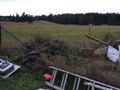
Retreating back to my car, I belatedly noticed a sign leaning up against a tree, opposite from the chicken run. Um... oops! Sorry...
Tracklog
Photos
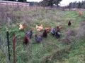
Chickens.
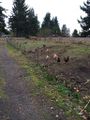
Chickens in pursuit!
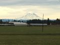
Beautiful shot of Mt. Ranier.
The hashpoint is over in that direction.
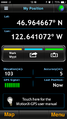
GPS readout.
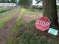
Oops...


