Difference between revisions of "2013-02-02 31 -3"
From Geohashing
imported>TFTD (Created page with "{{subst:Expedition |lat = 31 |lon = -3 |date = 2013-02-02 |image = 2013-02-02 31 -3.jpg) }}") |
imported>TFTD (Content) |
||
| Line 2: | Line 2: | ||
<!-- If you did not specify these parameters in the template, please substitute appropriate values for IMAGE, LAT, LON, and DATE (YYYY-MM-DD format) | <!-- If you did not specify these parameters in the template, please substitute appropriate values for IMAGE, LAT, LON, and DATE (YYYY-MM-DD format) | ||
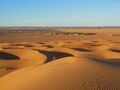
| − | [[Image:{{{image| | + | [[Image:{{{image|2013-02-02_31_-3.jpg}}}|thumb|left]] |
Remove this section if you don't want an image at the top (left) of your report. You should remove the "Image:" or "File:" | Remove this section if you don't want an image at the top (left) of your report. You should remove the "Image:" or "File:" | ||
| Line 19: | Line 19: | ||
== Location == | == Location == | ||
<!-- where you've surveyed the hash to be --> | <!-- where you've surveyed the hash to be --> | ||
| + | At the edge of the Sahara dessert in the dunes. | ||
== Participants == | == Participants == | ||
<!-- who attended: If you link to your wiki user name in this section, your expedition will be picked up by the various statistics generated for geohashing. You may use three tildes ~ as a shortcut to automatically insert the user signature of the account you are editing with. | <!-- who attended: If you link to your wiki user name in this section, your expedition will be picked up by the various statistics generated for geohashing. You may use three tildes ~ as a shortcut to automatically insert the user signature of the account you are editing with. | ||
--> | --> | ||
| + | [[User:TFTD | TFTD]] and other people around me. | ||
== Plans == | == Plans == | ||
| − | + | No plans back than, just realized today that I was really close by. | |
== Expedition == | == Expedition == | ||
| − | + | Overall nice trip at the edge of the dessert, but that was not because of geohashing. | |
| + | Picture taken at roughly [https://maps.google.de/maps?q=31.20814,-3.981564&num=1&t=h&z=15 31.20814,-3.981564]. And I spend the night at [https://maps.google.de/maps?q=31.217463,-3.979075&num=1&t=h&z=15 31.217463,-3.979075] | ||
== Tracklog == | == Tracklog == | ||
| Line 38: | Line 41: | ||
--> | --> | ||
<gallery perrow="5"> | <gallery perrow="5"> | ||
| + | Image:2013-02-02_31_-3.jpg | The red arrow approximately marks the location of the hash. | ||
</gallery> | </gallery> | ||
| Line 46: | Line 50: | ||
<!-- =============== USEFUL CATEGORIES FOLLOW ================ | <!-- =============== USEFUL CATEGORIES FOLLOW ================ | ||
| − | |||
| − | |||
| − | |||
| − | |||
| − | |||
| − | |||
| − | |||
| − | |||
| − | |||
| − | |||
| − | |||
[[Category:Expeditions]] | [[Category:Expeditions]] | ||
| − | |||
[[Category:Expeditions with photos]] | [[Category:Expeditions with photos]] | ||
| − | |||
[[Category:Expedition without GPS]] | [[Category:Expedition without GPS]] | ||
| − | |||
| − | |||
| − | |||
| − | |||
| − | |||
| − | |||
[[Category:Coordinates not reached]] | [[Category:Coordinates not reached]] | ||
| − | |||
| − | |||
| − | |||
| − | |||
| − | |||
| − | |||
| − | |||
| − | |||
| − | |||
| − | |||
| − | |||
[[Category:Not reached - Did not attempt]] | [[Category:Not reached - Did not attempt]] | ||
| − | |||
| − | |||
Revision as of 17:22, 16 March 2014
| Sat 2 Feb 2013 in 31,-3: 31.2335908, -3.9685229 geohashing.info google osm bing/os kml crox |
Location
At the edge of the Sahara dessert in the dunes.
Participants
TFTD and other people around me.
Plans
No plans back than, just realized today that I was really close by.
Expedition
Overall nice trip at the edge of the dessert, but that was not because of geohashing. Picture taken at roughly 31.20814,-3.981564. And I spend the night at 31.217463,-3.979075
Tracklog
Photos
The red arrow approximately marks the location of the hash.
