Difference between revisions of "2013-02-02 31 -3"
From Geohashing
imported>GeorgDerReisende |
imported>Fippe (Location) |
||
| (2 intermediate revisions by one other user not shown) | |||
| Line 5: | Line 5: | ||
}} | }} | ||
| − | + | ||
__NOTOC__ | __NOTOC__ | ||
== Location == | == Location == | ||
| − | + | ||
At the edge of the Sahara dessert in the dunes. | At the edge of the Sahara dessert in the dunes. | ||
== Participants == | == Participants == | ||
| − | + | ||
| − | + | * [[User:TFTD | TFTD]] and | |
| − | [[User:TFTD | TFTD]] and other people around me. | + | * other people around me. |
== Plans == | == Plans == | ||
| Line 21: | Line 21: | ||
== Expedition == | == Expedition == | ||
Overall nice trip at the edge of the dessert, but that was not because of geohashing. | Overall nice trip at the edge of the dessert, but that was not because of geohashing. | ||
| + | |||
Picture taken at roughly [https://maps.google.de/maps?q=31.20814,-3.981564&num=1&t=h&z=15 31.20814,-3.981564]. And I spend the night at [https://maps.google.de/maps?q=31.217463,-3.979075&num=1&t=h&z=15 31.217463,-3.979075] | Picture taken at roughly [https://maps.google.de/maps?q=31.20814,-3.981564&num=1&t=h&z=15 31.20814,-3.981564]. And I spend the night at [https://maps.google.de/maps?q=31.217463,-3.979075&num=1&t=h&z=15 31.217463,-3.979075] | ||
| − | |||
| − | |||
== Photos == | == Photos == | ||
| − | + | ||
| − | |||
| − | |||
<gallery perrow="5"> | <gallery perrow="5"> | ||
Image:2013-02-02_31_-3.jpg | The red arrow approximately marks the location of the hash. | Image:2013-02-02_31_-3.jpg | The red arrow approximately marks the location of the hash. | ||
| Line 43: | Line 40: | ||
[[Category:Coordinates not reached]] | [[Category:Coordinates not reached]] | ||
| − | [[Category:Not reached - | + | [[Category:Not reached - Time constraints]] |
| − | + | {{location|MA|08|ERR}} | |
| − | |||
Latest revision as of 23:27, 7 June 2019
| Sat 2 Feb 2013 in 31,-3: 31.2335908, -3.9685229 geohashing.info google osm bing/os kml crox |
Location
At the edge of the Sahara dessert in the dunes.
Participants
- TFTD and
- other people around me.
Plans
No plans back than, just realized today that I was really close by.
Expedition
Overall nice trip at the edge of the dessert, but that was not because of geohashing.
Picture taken at roughly 31.20814,-3.981564. And I spend the night at 31.217463,-3.979075
Photos
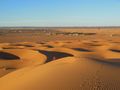
The red arrow approximately marks the location of the hash.
