Difference between revisions of "2014-05-17 48 10"
From Geohashing
imported>LeslieHapablap |
imported>LeslieHapablap (→Participants) |
||
| Line 24: | Line 24: | ||
<!-- who attended: If you link to your wiki user name in this section, your expedition will be picked up by the various statistics generated for geohashing. You may use three tildes ~ as a shortcut to automatically insert the user signature of the account you are editing with. | <!-- who attended: If you link to your wiki user name in this section, your expedition will be picked up by the various statistics generated for geohashing. You may use three tildes ~ as a shortcut to automatically insert the user signature of the account you are editing with. | ||
--> | --> | ||
| − | [[User:LeslieHapablap|LeslieHapablap]] | + | [[User:LeslieHapablap|LeslieHapablap]] ([[2014-04-16 47 11|previous]]|[[2014-05-18 47 11|next]]) |
== Plans == | == Plans == | ||
Revision as of 20:03, 20 May 2014
| Sat 17 May 2014 in 48,10: 48.7000745, 10.1952239 geohashing.info google osm bing/os kml crox |
Location
Near Heidenheim, right next to the A7 motorway.
Participants
LeslieHapablap (previous|next)
Plans
Again on my way back to Innsbruck, once more a convenient spot next to the motorway. Probably takes 20 minutes extra.
Expedition
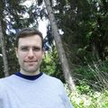
Everything went smooth. I walked the last few hundred meters, took some pictures and waited for anyone to arrive at meetup-o-clock (but nobody did). Unfortunately, Waltraud was not with me, and also EleanorAbernathy could not join on this expedition.
Photos
Achievements
LeslieHapablap earned the Land geohash achievement
|


