Difference between revisions of "2014-06-09 47 11"
imported>LeslieHapablap ([retro picture] Obligatory proof.) |
imported>LeslieHapablap |
||
| Line 19: | Line 19: | ||
== Location == | == Location == | ||
<!-- where you've surveyed the hash to be --> | <!-- where you've surveyed the hash to be --> | ||
| − | + | At a forest road near Grinzens. | |
== Participants == | == Participants == | ||
<!-- who attended: If you link to your wiki user name in this section, your expedition will be picked up by the various statistics generated for geohashing. You may use three tildes ~ as a shortcut to automatically insert the user signature of the account you are editing with. | <!-- who attended: If you link to your wiki user name in this section, your expedition will be picked up by the various statistics generated for geohashing. You may use three tildes ~ as a shortcut to automatically insert the user signature of the account you are editing with. | ||
--> | --> | ||
| − | + | [[User:LeslieHapablap|LeslieHapablap]] | |
== Plans == | == Plans == | ||
<!-- what were the original plans --> | <!-- what were the original plans --> | ||
| + | Go there by bike. | ||
== Expedition == | == Expedition == | ||
<!-- how it all turned out. your narrative goes here. --> | <!-- how it all turned out. your narrative goes here. --> | ||
| + | This geohash wasn't particularly hard, but today's heat made it challenging. I was familiar with most parts of the route from previous cycling tours, and therefore I knew in advance that I couldn't expect much shade. And indeed I needed much will power to continue on steadily rising roads with the sun burning without mercy. | ||
| + | |||
| + | Finally I made the 600m altitude difference to the village Grinzens and arrived at the point where the paved road turned into a forest road. From there I had to push my bike because it is not suited for these kind of roads, but luckily it was only half a kilometer more to go. | ||
| + | |||
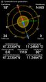
| + | I had to go a few steps into the forest to find the hash point and my GPS reception was quite poor once more. But I managed to get the 0m distance screenshot, albeit with a large uncertainty. | ||
| + | Happily with one more successful geohash I returned to Innsbruck. | ||
*I was there! -- [[User:LeslieHapablap|LeslieHapablap]] ([[User talk:LeslieHapablap|talk]]) 09:11, 9 June 2014 (EDT) | *I was there! -- [[User:LeslieHapablap|LeslieHapablap]] ([[User talk:LeslieHapablap|talk]]) 09:11, 9 June 2014 (EDT) | ||
Revision as of 23:31, 9 June 2014
| Mon 9 Jun 2014 in 47,11: 47.2230417, 11.2464164 geohashing.info google osm bing/os kml crox |
Location
At a forest road near Grinzens.
Participants
Plans
Go there by bike.
Expedition
This geohash wasn't particularly hard, but today's heat made it challenging. I was familiar with most parts of the route from previous cycling tours, and therefore I knew in advance that I couldn't expect much shade. And indeed I needed much will power to continue on steadily rising roads with the sun burning without mercy.
Finally I made the 600m altitude difference to the village Grinzens and arrived at the point where the paved road turned into a forest road. From there I had to push my bike because it is not suited for these kind of roads, but luckily it was only half a kilometer more to go.
I had to go a few steps into the forest to find the hash point and my GPS reception was quite poor once more. But I managed to get the 0m distance screenshot, albeit with a large uncertainty.
Happily with one more successful geohash I returned to Innsbruck.
- I was there! -- LeslieHapablap (talk) 09:11, 9 June 2014 (EDT)
Tracklog
Photos
Obligatory proof.

Achievements