Difference between revisions of "2015-01-06 47 -117"
imported>Thomcat ([live picture] [http://www.openstreetmap.org/?lat=47.59009000&lon=-117.40320249&zoom=16&layers=B000FTF @47.5901,-117.4032]) |
imported>FippeBot m (Location) |
||
| (2 intermediate revisions by one other user not shown) | |||
| Line 1: | Line 1: | ||
| − | |||
| − | |||
| − | |||
| − | |||
| − | |||
| − | |||
| − | |||
| − | |||
| − | |||
| − | |||
{{meetup graticule | {{meetup graticule | ||
| lat=47 | | lat=47 | ||
| lon=-117 | | lon=-117 | ||
| date=2015-01-06 | | date=2015-01-06 | ||
| + | | graticule_name=Spokane | ||
| + | | graticule_link=Spokane, Washington | ||
}} | }} | ||
| Line 18: | Line 10: | ||
__NOTOC__ | __NOTOC__ | ||
== Location == | == Location == | ||
| − | + | Rural location down the Latah creek. | |
== Participants == | == Participants == | ||
| − | + | * [[User:Thomcat|Thomcat]] | |
| − | + | ||
| + | == Expedition == | ||
| + | Just west of Spokane is a valley containing the Latah Creek (also known as Hangman River or Creek). Today's point was south along that valley, and an overhead view showed some sort of roads there (as opposed to many other locations along the creek). I had a spare hour to give it a try, plus I was able to visit a dog we fostered for a year nearby. | ||
| − | + | Drove the road leading to the hashpoint easily, including two interesting views (photoed on the way back). Upon reaching the looping roads pictured on google maps, I discovered they were behind a locked gate clearly marked No Trespassing. | |
| − | |||
| − | + | Sites seen on the way back were a gorgeous vista (and behind me as I snapped the picture was the deck of a house and a hot tub - excellent choice!) and a hillside which I am amazed hasn't collapsed in the recent rain. I'll leave it to the more geologically inclined to comment, but these rolling folds were quite interesting to observe. My best guess is glacial action - we are quite a ways east of the volcanic region. | |
| − | |||
| − | + | Hoping for a decent expedition tomorrow as I travel back to Seattle. | |
| − | |||
== Photos == | == Photos == | ||
| Line 44: | Line 35: | ||
Image:2015-01-06_47_-117_thomcat_1420586754866.jpg | [http://www.openstreetmap.org/?lat=47.59009000&lon=-117.40320249&zoom=16&layers=B000FTF @47.5901,-117.4032] | Image:2015-01-06_47_-117_thomcat_1420586754866.jpg | [http://www.openstreetmap.org/?lat=47.59009000&lon=-117.40320249&zoom=16&layers=B000FTF @47.5901,-117.4032] | ||
| + | |||
| + | Image:2015-01-06_47_-117_detail.jpg | slightly better detail | ||
</gallery> | </gallery> | ||
| − | |||
| − | |||
| − | |||
| − | |||
| − | |||
| − | |||
| − | |||
| − | |||
| − | |||
| − | |||
| − | |||
| − | |||
| − | |||
| − | |||
| − | |||
| − | |||
| − | |||
[[Category:Expeditions]] | [[Category:Expeditions]] | ||
| − | |||
[[Category:Expeditions with photos]] | [[Category:Expeditions with photos]] | ||
| − | |||
| − | |||
| − | |||
| − | |||
| − | |||
| − | |||
| − | |||
| − | |||
| − | |||
[[Category:Coordinates not reached]] | [[Category:Coordinates not reached]] | ||
| − | |||
| − | |||
| − | |||
| − | |||
| − | |||
[[Category:Not reached - No public access]] | [[Category:Not reached - No public access]] | ||
| − | + | {{location|US|WA|SP}} | |
| − | |||
| − | |||
| − | |||
| − | |||
| − | |||
| − | |||
| − | |||
Latest revision as of 02:21, 15 August 2019
| Tue 6 Jan 2015 in Spokane: 47.5115288, -117.3650015 geohashing.info google osm bing/os kml crox |
Location
Rural location down the Latah creek.
Participants
Expedition
Just west of Spokane is a valley containing the Latah Creek (also known as Hangman River or Creek). Today's point was south along that valley, and an overhead view showed some sort of roads there (as opposed to many other locations along the creek). I had a spare hour to give it a try, plus I was able to visit a dog we fostered for a year nearby.
Drove the road leading to the hashpoint easily, including two interesting views (photoed on the way back). Upon reaching the looping roads pictured on google maps, I discovered they were behind a locked gate clearly marked No Trespassing.
Sites seen on the way back were a gorgeous vista (and behind me as I snapped the picture was the deck of a house and a hot tub - excellent choice!) and a hillside which I am amazed hasn't collapsed in the recent rain. I'll leave it to the more geologically inclined to comment, but these rolling folds were quite interesting to observe. My best guess is glacial action - we are quite a ways east of the volcanic region.
Hoping for a decent expedition tomorrow as I travel back to Seattle.
Photos
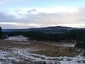
Looking towards Spokane @47.5132,-117.3784
slightly better detail


