Difference between revisions of "2015-01-07 47 -117"
From Geohashing
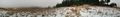
imported>Thomcat ([live picture] Lunch panorama [http://www.openstreetmap.org/?lat=47.00689120&lon=-120.56982680&zoom=16&layers=B000FTF @47.0069,-120.5698]) |
imported>Thomcat ([live picture] Another hour, another foggy lake. [http://www.openstreetmap.org/?lat=47.59026431&lon=-122.28056716&zoom=16&layers=B000FTF @47.5903,-122.2806]) |
||
| Line 40: | Line 40: | ||
Image:2015-01-07_47_-117_thomcat_1420656704565.jpg | Lunch panorama [http://www.openstreetmap.org/?lat=47.00689120&lon=-120.56982680&zoom=16&layers=B000FTF @47.0069,-120.5698] | Image:2015-01-07_47_-117_thomcat_1420656704565.jpg | Lunch panorama [http://www.openstreetmap.org/?lat=47.00689120&lon=-120.56982680&zoom=16&layers=B000FTF @47.0069,-120.5698] | ||
| + | |||
| + | Image:2015-01-07_47_-117_thomcat_1420663329154.jpg | Another hour, another foggy lake. [http://www.openstreetmap.org/?lat=47.59026431&lon=-122.28056716&zoom=16&layers=B000FTF @47.5903,-122.2806] | ||
</gallery> | </gallery> | ||
[[Category:Expeditions]] | [[Category:Expeditions]] | ||
[[Category:Expeditions with photos]] | [[Category:Expeditions with photos]] | ||
Revision as of 20:43, 7 January 2015
| Wed 7 Jan 2015 in Spokane: 47.5741186, -117.3896544 geohashing.info google osm bing/os kml crox |
Location
Just off Hangman Valley Road, north of previous day's location
Participants
Plans
Visit geohash at sunrise (7:37 am) and get out of town.
Expedition
Photos
Latah creek @47.5755,-117.3905
Pano at sunrise @47.5871,-117.4007

Sunrise + 2 hours @47.1042,-119.3559
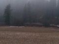
Sunrise +3 hours @47.0075,-120.5713

Lunch panorama @47.0069,-120.5698
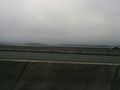
Another hour, another foggy lake. @47.5903,-122.2806


