Difference between revisions of "2015-02-14 54 -2"
From Geohashing
imported>Angel ([live picture] [http://www.openstreetmap.org/?lat=54.06930000&lon=-2.81030000&zoom=16&layers=B000FTF @54.0693,-2.8103]) |
imported>Angel (I guess this is where the new motorway is going to cross the canal :S [http://www.openstreetmap.org/?lat=54.06900000&lon=-2.80920000&zoom=16&layers=B000FTF @54.0690,-2.8092]) |
||
| Line 52: | Line 52: | ||
Image:2015-02-14_54_-2_angel_1423935964778.jpg | [http://www.openstreetmap.org/?lat=54.06930000&lon=-2.81030000&zoom=16&layers=B000FTF @54.0693,-2.8103] | Image:2015-02-14_54_-2_angel_1423935964778.jpg | [http://www.openstreetmap.org/?lat=54.06930000&lon=-2.81030000&zoom=16&layers=B000FTF @54.0693,-2.8103] | ||
| + | |||
| + | Image:2015-02-14_54_-2_angel_1423935850324.jpg | I guess this is where the new motorway is going to cross the canal :S [http://www.openstreetmap.org/?lat=54.06900000&lon=-2.80920000&zoom=16&layers=B000FTF @54.0690,-2.8092] | ||
</gallery> | </gallery> | ||
Revision as of 18:00, 14 February 2015
| Sat 14 Feb 2015 in 54,-2: 54.0697436, -2.8113111 geohashing.info google osm bing/os kml crox |
Location
Participants
Plans
Expedition
- Feeling sick, feeling dizzy. This should have been an easy one, but having only just got out of bed makes it a challenge. -- Angel (talk) @54.0311,-2.7943 10:59, 14 February 2015 (EST)
Tracklog
Endomondo tracklog from my phone
Photos
View from the hash... as far as I can tell, the exact point might be here, or might be on the closed part of the path
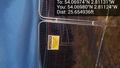
10 feet away; best I can get @54.0697,-2.8113
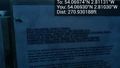
270 feet away, a diversion sign. Thought I'd failed! @54.0693,-2.8103
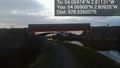
I guess this is where the new motorway is going to cross the canal :S @54.0690,-2.8092


Achievements