Difference between revisions of "2015-03-19 -35 149"
imported>1PE m (→Plans) |
imported>1PE |
||
| Line 12: | Line 12: | ||
| lat=-35 | | lat=-35 | ||
| lon=149 | | lon=149 | ||
| − | | date= | + | | date=2015-03-19 |
}} | }} | ||
| Line 18: | Line 18: | ||
__NOTOC__ | __NOTOC__ | ||
== Location == | == Location == | ||
| − | In the 'home' paddock of a rural farm | + | In the 'home' paddock of a rural farm at Wallaroo near Hall, a village near Canberra ACT. |
| − | This is just off the | + | This is just off the Barton Highway from Canberra (the national capital) to Yass, where it joins the Hume Highway, the main eastern inland route in Australia, between Sydney and Melbourne. |
== Participants == | == Participants == | ||
| + | ===[[User:1PE|1PE]]=== | ||
<!-- who attended: If you link to your wiki user name in this section, your expedition will be picked up by the various statistics generated for geohashing. You may use three tildes ~ as a shortcut to automatically insert the user signature of the account you are editing with. | <!-- who attended: If you link to your wiki user name in this section, your expedition will be picked up by the various statistics generated for geohashing. You may use three tildes ~ as a shortcut to automatically insert the user signature of the account you are editing with. | ||
--> | --> | ||
| Line 32: | Line 33: | ||
== Expedition == | == Expedition == | ||
| + | ===[[User:1PE|1PE]]=== | ||
| + | I drove west out along the Barton Highway and was past the entrance before I realised it. I turned around and returned, past the historic church on the north side of the road. I parked my car opposite the gated entrance to the property, and walked across between the streams of cars. | ||
| + | |||
| + | The entrance has several historic names, one the name of the property and the other then occupants, a well know name of early European settlers of the region. For reasons of privacy, I will not name them. | ||
| + | |||
| + | I took several pictures at the locked gate and looking up the hill where the hash point is obscured by some trees. | ||
| + | |||
| + | I left an explanation of geohashing that invites them to document the actual hash. | ||
<!-- how it all turned out. your narrative goes here. --> | <!-- how it all turned out. your narrative goes here. --> | ||
| Line 42: | Line 51: | ||
--> | --> | ||
<gallery perrow="5"> | <gallery perrow="5"> | ||
| + | image:2015-03-19_-35_149_17.14.00.jpg|Gate entrance closing off access to the hash that is up the hill close to the road behind the tree. | ||
| + | image:2015-03-19_-35_149_17.15.11.jpg|Sheep in a paddock near the gate. Note the dam that is looking well stocked. | ||
</gallery> | </gallery> | ||
| Line 60: | Line 71: | ||
--> | --> | ||
| + | |||
| + | [[Category:Expeditions]] | ||
| + | |||
| + | [[Category:Expeditions with photos]] | ||
<!-- An actual expedition: | <!-- An actual expedition: | ||
| − | |||
-- and one or more of -- | -- and one or more of -- | ||
| − | |||
[[Category:Expeditions with videos]] | [[Category:Expeditions with videos]] | ||
[[Category:Expedition without GPS]] | [[Category:Expedition without GPS]] | ||
Revision as of 08:23, 19 March 2015
| Thu 19 Mar 2015 in -35,149: -35.1545414, 149.0571906 geohashing.info google osm bing/os kml crox |
Location
In the 'home' paddock of a rural farm at Wallaroo near Hall, a village near Canberra ACT. This is just off the Barton Highway from Canberra (the national capital) to Yass, where it joins the Hume Highway, the main eastern inland route in Australia, between Sydney and Melbourne.
Participants
1PE
Plans
1PE
On the drive home from work, go past my home out to the hash and at least get to the farm gate and (1) take a pic from there, and (2) drop a map/message in the mailbox.
Expedition
1PE
I drove west out along the Barton Highway and was past the entrance before I realised it. I turned around and returned, past the historic church on the north side of the road. I parked my car opposite the gated entrance to the property, and walked across between the streams of cars.
The entrance has several historic names, one the name of the property and the other then occupants, a well know name of early European settlers of the region. For reasons of privacy, I will not name them.
I took several pictures at the locked gate and looking up the hill where the hash point is obscured by some trees.
I left an explanation of geohashing that invites them to document the actual hash.
Tracklog
Photos
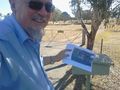
Gate entrance closing off access to the hash that is up the hill close to the road behind the tree.
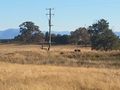
Sheep in a paddock near the gate. Note the dam that is looking well stocked.


Achievements