Difference between revisions of "2015-04-27 39 -89"
imported>Mystrsyko (→Expedition) |
imported>FippeBot m (Location) |
||
| (2 intermediate revisions by one other user not shown) | |||
| Line 17: | Line 17: | ||
== Expedition == | == Expedition == | ||
| − | + | [[File:2015-04-27 39 -89 frown.jpg|200px|thumb|left|Stupid frown]] | |
| + | For once there is a point close to home, but alas, it seemed to be in someone's yard. However, it seemed there was no fence around the yard and that the point may be near enough a sidewalk that I could get within my GPS margin of error, so off I went. | ||
| + | |||
| + | Convieniently, the neighborhood the point lay in happened to be right off the bike trail near my house. So I hopped on it, and despite forgetting exactly where I needed to leave the trail, I was able to find the 4 lane road called Bradfordton that ran past the point. To my surprise, Bradfordton begins at the bike trail (no car access) and ends just a quarter mile or so farther north at a farm field (with no car access), so why they felt the need to make it four lanes is not known to me. | ||
| + | |||
| + | I approached the hash from the west side on Bradfordton and discovered why Google Maps is not a reliable tool for planning geohashing expeditions. It would seem that sometime between the satellite image on Google and the present, the owners of the house had erected a privacy fence on their property. Even without the fence, however, the point was still well outside my margin of error, which due to the clear sunny skies and lack of tall buildings or trees, was extremely small. I decided to go around and approach the point from the front of the homes, but again, was denied by the surprisingly small margin, and with no cars in either of the home's driveways (a universal sign of nobody being home in the suburbs) I decided to call it a day and head home. | ||
| + | |||
| + | On the way back, I discovered that I had forgotten to turn my GPS tracking app back on after I shut it off near the hash point, so my track log is missing some distance in there. | ||
== Tracklog == | == Tracklog == | ||
| − | + | https://www.strava.com/activities/293686440 | |
== Photos == | == Photos == | ||
| − | < | + | |
| − | Image: | + | <gallery perrow="4"> |
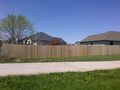
| − | -- | + | Image:2015-04-27 39 -89 fence.jpg|Fence that Google said wasn't there |
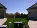
| − | + | Image:2015-04-27 39 -89 hash.jpg|It's right there! Darn! | |
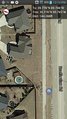
| + | Image:2015-04-27 39 -89 screenshot1.png|Proof Google doesn't know everything | ||
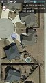
| + | Image:2015-04-27 39 -89 screenshot2.png|As close as I could get without tresspassing | ||
</gallery> | </gallery> | ||
== Achievements == | == Achievements == | ||
{{#vardefine:ribbonwidth|800px}} | {{#vardefine:ribbonwidth|800px}} | ||
| − | + | {{No trespassing | |
| − | |||
| − | |||
| − | |||
| − | |||
| − | |||
| − | + | | latitude = 39 | |
| + | | longitude = -89 | ||
| + | | date = 2015-04-27 | ||
| + | | name = Mystrsyko | ||
| + | | distance = 60ft | ||
| − | + | }} | |
| − | |||
| − | |||
| − | |||
| − | |||
[[Category:Expeditions]] | [[Category:Expeditions]] | ||
| − | |||
[[Category:Expeditions with photos]] | [[Category:Expeditions with photos]] | ||
| − | |||
| − | |||
| − | |||
| − | |||
| − | |||
| − | |||
| − | |||
| − | |||
| − | |||
[[Category:Coordinates not reached]] | [[Category:Coordinates not reached]] | ||
| − | |||
| − | |||
| − | |||
| − | |||
| − | |||
[[Category:Not reached - No public access]] | [[Category:Not reached - No public access]] | ||
| − | + | {{location|US|IL|SM}} | |
| − | |||
| − | |||
| − | |||
| − | |||
| − | |||
| − | |||
| − | |||
Latest revision as of 03:28, 15 August 2019
| Mon 27 Apr 2015 in 39,-89: 39.7763553, -89.7457213 geohashing.info google osm bing/os kml crox |
Location
In a yard on the west side of Springfield.
Participants
Plans
Going to head there and see if I can get within my margin of error. - Mystrsyko (talk)
Expedition

For once there is a point close to home, but alas, it seemed to be in someone's yard. However, it seemed there was no fence around the yard and that the point may be near enough a sidewalk that I could get within my GPS margin of error, so off I went.
Convieniently, the neighborhood the point lay in happened to be right off the bike trail near my house. So I hopped on it, and despite forgetting exactly where I needed to leave the trail, I was able to find the 4 lane road called Bradfordton that ran past the point. To my surprise, Bradfordton begins at the bike trail (no car access) and ends just a quarter mile or so farther north at a farm field (with no car access), so why they felt the need to make it four lanes is not known to me.
I approached the hash from the west side on Bradfordton and discovered why Google Maps is not a reliable tool for planning geohashing expeditions. It would seem that sometime between the satellite image on Google and the present, the owners of the house had erected a privacy fence on their property. Even without the fence, however, the point was still well outside my margin of error, which due to the clear sunny skies and lack of tall buildings or trees, was extremely small. I decided to go around and approach the point from the front of the homes, but again, was denied by the surprisingly small margin, and with no cars in either of the home's driveways (a universal sign of nobody being home in the suburbs) I decided to call it a day and head home.
On the way back, I discovered that I had forgotten to turn my GPS tracking app back on after I shut it off near the hash point, so my track log is missing some distance in there.
Tracklog
https://www.strava.com/activities/293686440
Photos
Fence that Google said wasn't there
It's right there! Darn!
Proof Google doesn't know everything
As close as I could get without tresspassing


Achievements
Mystrsyko earned the No trespassing consolation prize
|