Difference between revisions of "2015-05-07 53 -2"
imported>Marsh (→Photos) |
imported>Marsh (→Photos) |
||
| Line 47: | Line 47: | ||
2015-05-08 GPS2.png | Close but no direct access | 2015-05-08 GPS2.png | Close but no direct access | ||
</gallery> | </gallery> | ||
| + | |||
| + | == Achievements == | ||
| + | {{#vardefine:ribbonwidth|800px}} | ||
| + | <!-- Add any achievement ribbons you earned below, or remove this section --> | ||
| + | |||
| + | |||
| + | <!-- =============== USEFUL CATEGORIES FOLLOW ================ | ||
| + | Delete the next line ONLY if you have chosen the appropriate categories below. If you are unsure, don't worry. People will read your report and help you with the classification.--> | ||
| + | [[Category:New report]] | ||
| + | |||
| + | <!-- ==REQUEST FOR TWITTER BOT== Please leave either the New report or the Expedition planning category in as long as you work on it. This helps the twitter bot a lot with announcing the right outcome at the right moment. --> | ||
| + | |||
| + | <!-- Potential categories. Please include all the ones appropriate to your expedition --> | ||
| + | <!-- If this is a planning page: | ||
| + | [[Category:Expedition planning]] | ||
| + | --> | ||
| + | |||
| + | <!-- An actual expedition: | ||
| + | [[Category:Expeditions]] | ||
| + | -- and one or more of -- | ||
| + | [[Category:Expeditions with photos]] | ||
| + | [[Category:Expeditions with videos]] | ||
| + | [[Category:Expedition without GPS]] | ||
| + | --> | ||
| + | |||
| + | <!-- if you reached your coords: | ||
| + | [[Category:Coordinates reached]] | ||
| + | |||
| + | |||
| + | --><!-- or if you failed :( | ||
| + | [[Category:Coordinates not reached]] | ||
| + | -- and a reason -- | ||
| + | When there is a natural obstacle between you and the target: | ||
| + | [[Category:Not reached - Mother Nature]] | ||
| + | |||
| + | When there is a man-made obstacle between you and the target: | ||
| + | [[Category:Not reached - No public access]] | ||
| + | |||
| + | When you failed get your GPS, car, bike or such to work: | ||
| + | [[Category:Not reached - Technology]] | ||
| + | |||
| + | When you went to an alternate location instead of the actual geohash: | ||
| + | [[Category:Not reached - Did not attempt]] | ||
Revision as of 16:17, 8 May 2015
| Thu 7 May 2015 in 53,-2: 53.5728423, -2.7119334 geohashing.info google osm bing/os kml crox |
Location
The geohash is in Appley Bridge, an area within the Wigan borough. The geohash is located inside a field, towards its upper edge. The field is next to a residential area. Houses surround the geohash to the north and east with some trees present in-between. To the west are train tracks and to the south is what appears to be a private farmhouse.
Participants
Plans
The plan was to take a train from Wigan Wallgate station to Appley Bridge station, covering most of the distance. From there I would walk through residential streets and through the field's adjacent dirt trail. I wasn't sure what I'd do at this point. I was hopeful that I'd find a public route going past the geohash. Alternatively I hoped the field was public, or that I could get permission from the landowner to enter it.
Expedition
This was my second geohasing attempt and the first to end in failure. I took the train from Wallgate to Appley Bridge as planned. Of note, the train went immediately past the geohash and I observed that the field was free of animals (possibly supporting my right to enter it.) I'd never been to Appley Bridge before and found the place to be very hilly and twisty. However I managed to navigate towards the streets closest to the geohash by using my phone's GPS. I located the field's adjacent dirt trail but found a closed gate in my way alongside a sign that claimed the area was private. Not to be defeated I visited several other nearby streets hoping to find an entrance. I walked to the nearby train tracks and tried to walk alongside them (there was a metal fence in-between me and the tracks), however the trees became too thick to continue. Regardless I would have ended up in many people's back gardens before I had reached the field. After traveling up and down nearby streets for twenty minutes I admitted defeat and returned to the fence. I knew there was a farmhouse down the trail but I could not walk down it to ask the landowner's permission without trespassing. I gathered some nearby twigs and spelt out 'xkcd' as a marker. Although certain points of nearby streets were technically closer to the geohash, I counted the field as the last reasonable point that it was possible to reach. I snapped a few pictures and returned home. Ahh well, there's always next time. The Wigan area doesn't seem to get the geohash much but it's been cropping up a little bit since I started.
Photos
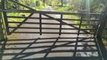
The gate that blocked my way (marker visible)
At the gate facing the direction of the geohash
At the gate
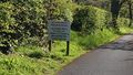
"NO FOOTPATH PRIVATE ROAD ACCESS ONLY TO VALLEY VIEW COTTAGE & BROADRIDING FARM HOUSE"
Closeup of the marker
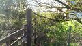
At the train tracks facing the geohash. There was a hopeful path but it could not take me there.
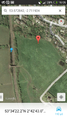
My train went right past the geohash
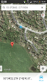
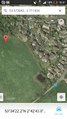
Close but no direct access


Achievements