Difference between revisions of "1993-05-21 49 19"
imported>Malgond |
imported>FippeBot m (Location) |
||
| (11 intermediate revisions by one other user not shown) | |||
| Line 20: | Line 20: | ||
== Plans == | == Plans == | ||
| − | + | ||
| + | It was my first Geohashing Day since I started playing the game, so I was quite eager to observe it. However, it was Thursday, and quite a busy one, with important family activities both in the morning and in the evening - and it was a normal work/school/kindergarten day for us. So there was no time for any serious expedition. Therefore I have resolved to try finding some easy retrohash. | ||
| + | |||
| + | I kept clicking on the Eupheodes' map until I got something easy and close to home. So this is it - a street in a town just a few kilometers west of our home. | ||
== Expedition == | == Expedition == | ||
| − | |||
| − | + | We've arrived at the place about 9 p.m. so it was getting dark already - and raining. I have parked our car in an empty lot just next to the hash and we went through a lenghty photo session with me fiddling with camera settings and all of us in turn trying to make some steady shot in poor conditions while some of the others were walking across the street. | |
| − | |||
== Photos == | == Photos == | ||
| − | < | + | |
| − | Image: | + | <gallery perrow="4"> |
| − | -- | + | Image:1993-05-21 49 19-1.jpeg|View to the west |
| − | + | Image:1993-05-21 49 19-2.jpeg|And another one | |
| + | Image:1993-05-21 49 19-3.jpeg|View to the east | ||
| + | Image:1993-05-21 49 19-4.jpeg|And still another | ||
| + | Image:1993-05-21 49 19-5.jpeg|View to the south-east towards a chapel | ||
| + | Image:1993-05-21 49 19-6.jpeg|And another one | ||
| + | Image:1993-05-21 49 19-7.jpeg|The chapel alone | ||
| + | Image:1993-05-21 49 19-8.jpeg|A happy young geohasher | ||
</gallery> | </gallery> | ||
| − | |||
| − | |||
| − | |||
| + | Proof by Google Street View: | ||
| − | + | [[File:1993-05-21_49_19-street_view.png]] | |
| − | |||
| − | |||
| − | + | == Achievements == | |
| − | + | {{#vardefine:ribbonwidth|800px}} | |
| − | + | [[Category:Poland]] | |
| − | + | [[Category:Retro coordinates reached]] | |
| − | [[Category: | ||
| − | |||
| − | |||
| − | |||
| − | [[Category: | ||
| − | |||
[[Category:Expeditions with photos]] | [[Category:Expeditions with photos]] | ||
| − | |||
[[Category:Expedition without GPS]] | [[Category:Expedition without GPS]] | ||
| − | |||
| − | |||
| − | |||
| − | |||
| − | |||
| − | |||
| − | |||
| − | |||
| − | |||
| − | |||
| − | |||
| − | |||
| − | |||
| − | |||
| − | |||
| − | |||
| − | |||
| − | |||
| − | |||
| − | |||
| − | + | {{Geohashing Day | |
| + | | latitude = 49 | ||
| + | | longitude = 19 | ||
| + | | year = 2015 | ||
| + | | coorddate= 1993-05-21 | ||
| + | | name = [[User:Malgond|Malgond]] | ||
| + | }} | ||
| + | {{location|PL|K|RA}} | ||
Latest revision as of 03:54, 7 August 2019
| Fri 21 May 1993 in 49,19: 49.9750135, 19.8287327 geohashing.info google osm bing/os kml crox |
Retrohashing to celebrate Geohashing Day.
Location
On the pedestrian crosswalk in the Kazimierza Wielkiego street in Skawina, Poland
Participants
Malgond, his boys and father-in-law.
Plans
It was my first Geohashing Day since I started playing the game, so I was quite eager to observe it. However, it was Thursday, and quite a busy one, with important family activities both in the morning and in the evening - and it was a normal work/school/kindergarten day for us. So there was no time for any serious expedition. Therefore I have resolved to try finding some easy retrohash.
I kept clicking on the Eupheodes' map until I got something easy and close to home. So this is it - a street in a town just a few kilometers west of our home.
Expedition
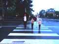
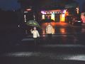
We've arrived at the place about 9 p.m. so it was getting dark already - and raining. I have parked our car in an empty lot just next to the hash and we went through a lenghty photo session with me fiddling with camera settings and all of us in turn trying to make some steady shot in poor conditions while some of the others were walking across the street.
Photos
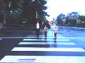
View to the west
And another one
View to the east

And still another

View to the south-east towards a chapel

And another one
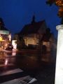
The chapel alone

A happy young geohasher


Proof by Google Street View:

Achievements
Malgond earned the 2015 Geohashing Day achievement
|