Difference between revisions of "2015-05-31 51 -2"
From Geohashing
imported>Geeoharee (Created page with "{{subst:Expedition |lat =51 |lon =-2 |date =2015-05-31 }}") |
imported>Geeoharee |
||
| Line 1: | Line 1: | ||
| − | |||
| − | |||
| − | |||
| − | |||
| − | |||
| − | |||
| − | |||
| − | |||
| − | |||
| − | |||
{{meetup graticule | {{meetup graticule | ||
| lat=51 | | lat=51 | ||
| Line 15: | Line 5: | ||
}} | }} | ||
| − | |||
__NOTOC__ | __NOTOC__ | ||
== Location == | == Location == | ||
| − | + | ||
| + | About as close to the England-Wales border as it could be. A field near Monmouth, north of Cottage Farm and south of Perth-Hir Grove. The river Monnow forms the border here, and the hash is in the middle of a >-shaped meander. | ||
== Participants == | == Participants == | ||
| − | + | ||
| − | + | [[User:Geeoharee|Geeoharee]] ([[User talk:Geeoharee|talk]]) | |
== Plans == | == Plans == | ||
| − | + | ||
| + | Finished my chores for the day and the sun is coming out, so why not try for the border achievement? Turn right off the B4347, park up and walk through fields, dealing with obstacles as they occur. | ||
== Expedition == | == Expedition == | ||
| Line 34: | Line 25: | ||
== Photos == | == Photos == | ||
| − | |||
| − | |||
| − | |||
<gallery perrow="5"> | <gallery perrow="5"> | ||
| + | Image:20150531bristolposter.png | The goal | ||
</gallery> | </gallery> | ||
| Line 48: | Line 37: | ||
Delete the next line ONLY if you have chosen the appropriate categories below. If you are unsure, don't worry. People will read your report and help you with the classification.--> | Delete the next line ONLY if you have chosen the appropriate categories below. If you are unsure, don't worry. People will read your report and help you with the classification.--> | ||
[[Category:New report]] | [[Category:New report]] | ||
| + | [[Category:Expedition planning]] | ||
<!-- ==REQUEST FOR TWITTER BOT== Please leave either the New report or the Expedition planning category in as long as you work on it. This helps the twitter bot a lot with announcing the right outcome at the right moment. --> | <!-- ==REQUEST FOR TWITTER BOT== Please leave either the New report or the Expedition planning category in as long as you work on it. This helps the twitter bot a lot with announcing the right outcome at the right moment. --> | ||
Revision as of 14:54, 31 May 2015
| Sun 31 May 2015 in 51,-2: 51.8420975, -2.7544326 geohashing.info google osm bing/os kml crox |
Location
About as close to the England-Wales border as it could be. A field near Monmouth, north of Cottage Farm and south of Perth-Hir Grove. The river Monnow forms the border here, and the hash is in the middle of a >-shaped meander.
Participants
Plans
Finished my chores for the day and the sun is coming out, so why not try for the border achievement? Turn right off the B4347, park up and walk through fields, dealing with obstacles as they occur.
Expedition
Tracklog
Photos
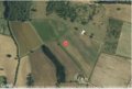
The goal

Achievements