Difference between revisions of "1988-10-04 49 11"
From Geohashing
imported>Klaus (planning) |
imported>Klaus (expedition and photo upload) |
||
| Line 1: | Line 1: | ||
| − | |||
| − | |||
| − | |||
| − | |||
| − | |||
| − | |||
| − | |||
| − | |||
| − | |||
| − | |||
{{meetup graticule | {{meetup graticule | ||
| lat=49 | | lat=49 | ||
| Line 15: | Line 5: | ||
| retro=1 | | retro=1 | ||
}} | }} | ||
| + | |||
| + | [[Image:{{{image|1988-10-04_retro_proof.jpg}}}|thumb|left]] | ||
<!-- edit as necessary --> | <!-- edit as necessary --> | ||
| Line 24: | Line 16: | ||
== Participants == | == Participants == | ||
| − | * [[User:Klaus|Klaus]] | + | * [[User:Klaus|Klaus]] |
| + | * his brother | ||
== Plans == | == Plans == | ||
visit the easy geohash either on the evening of 17th or 19th of July, as I arrive/leave from the train station in Bayreuth then anyway. | visit the easy geohash either on the evening of 17th or 19th of July, as I arrive/leave from the train station in Bayreuth then anyway. | ||
| + | |||
== Expedition == | == Expedition == | ||
| − | + | I arrived at the train station at around 18:45 on July 17th, 2015. | |
| + | I met with my brother and we both made a little detour (2km) to visit my origin geohash. | ||
| + | |||
| + | We drove to the geohash by car, left it for 1-2 minutes and then drove to our actual destination... | ||
| + | We only stayed ~1 minute at the geohash, because there was nothing much to see and my brother is not yet convinced about geohasing :) | ||
| + | |||
| + | Anyway, coordinates reached! | ||
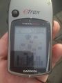
== Tracklog == | == Tracklog == | ||
| − | + | ||
| + | see below | ||
== Photos == | == Photos == | ||
<!-- Insert pictures between the gallery tags using the following format: | <!-- Insert pictures between the gallery tags using the following format: | ||
| − | |||
--> | --> | ||
<gallery perrow="5"> | <gallery perrow="5"> | ||
| + | Image:1988-10-04 49 11 retro Zoomlevel 15.png | Tracklog | ||
| + | Image:1988-10-04 retro proof.jpg | Proof | ||
| + | Image:1988-10-04 retro view.jpg | View from geohash | ||
| + | |||
</gallery> | </gallery> | ||
== Achievements == | == Achievements == | ||
{{#vardefine:ribbonwidth|800px}} | {{#vardefine:ribbonwidth|800px}} | ||
| − | |||
| − | + | {{origin geohash | |
| − | [[ | + | | latitude = 49 |
| + | | longitude = 11 | ||
| + | | date = 1988-10-04 | ||
| + | | on = 2015-07-17 | ||
| + | | name = [[User:Klaus|Klaus]] | ||
| + | | image = 1988-10-04 retro view.jpg | ||
| + | }} | ||
| − | |||
| − | |||
[[Category:Expeditions]] | [[Category:Expeditions]] | ||
| − | + | [[Category:Expeditions with photos]] | |
| − | [[Category:Expeditions with photos]] | + | [[Category:Origin reached]] |
| − | [[Category: | ||
| − | |||
| − | |||
| − | |||
| − | |||
| − | |||
| − | |||
| − | |||
| − | |||
| − | |||
| − | |||
| − | |||
| − | |||
| − | |||
| − | |||
| − | |||
| − | |||
| − | |||
| − | |||
| − | |||
| − | |||
| − | |||
| − | |||
| − | |||
Revision as of 22:10, 17 July 2015
| Tue 4 Oct 1988 in 49,11: 49.9358720, 11.5844382 geohashing.info google osm bing/os kml crox |

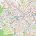
Location
This is the Origin geohash of Klaus. It's in Bayreuth on or on the sidewalk of Jean-Paul-Strasse, very near to the university where I studied.
Participants
- Klaus
- his brother
Plans
visit the easy geohash either on the evening of 17th or 19th of July, as I arrive/leave from the train station in Bayreuth then anyway.
Expedition
I arrived at the train station at around 18:45 on July 17th, 2015. I met with my brother and we both made a little detour (2km) to visit my origin geohash.
We drove to the geohash by car, left it for 1-2 minutes and then drove to our actual destination... We only stayed ~1 minute at the geohash, because there was nothing much to see and my brother is not yet convinced about geohasing :)
Anyway, coordinates reached!
Tracklog
see below
Photos
Tracklog
Proof
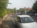
View from geohash


Achievements
Klaus earned the Origin geohash achievement
|