Difference between revisions of "2015-07-17 49 11"
From Geohashing
imported>Schnatterfleck (Another watering device. In the background you can make out the tower of Nuremberg's airport. [http://www.openstreetmap.org/?lat=49.50320000&lon=11.05060000&zoom=16&layers=B000FTF @49.5032,11.0506]) |
imported>Schnatterfleck (This watering device is located right at the hashpoint. [http://www.openstreetmap.org/?lat=49.51250000&lon=11.04330000&zoom=16&layers=B000FTF @49.5125,11.0433]) |
||
| Line 45: | Line 45: | ||
Image:2015-07-17_49_11_Schnatterfleck_-1.jpg | Another watering device. In the background you can make out the tower of Nuremberg's airport. [http://www.openstreetmap.org/?lat=49.50320000&lon=11.05060000&zoom=16&layers=B000FTF @49.5032,11.0506] | Image:2015-07-17_49_11_Schnatterfleck_-1.jpg | Another watering device. In the background you can make out the tower of Nuremberg's airport. [http://www.openstreetmap.org/?lat=49.50320000&lon=11.05060000&zoom=16&layers=B000FTF @49.5032,11.0506] | ||
| + | |||
| + | Image:2015-07-17_49_11_Schnatterfleck_1437136367233.jpg | This watering device is located right at the hashpoint. [http://www.openstreetmap.org/?lat=49.51250000&lon=11.04330000&zoom=16&layers=B000FTF @49.5125,11.0433] | ||
</gallery> | </gallery> | ||
Revision as of 13:48, 17 July 2015
| Fri 17 Jul 2015 in 49,11: 49.5124496, 11.0433368 geohashing.info google osm bing/os kml crox |
Location
Participants
Plans
Expedition
Tracklog
Photos
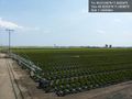
Massively parallel automated plant pot watering @49.5014,11.0523
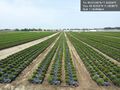
Enough little patio greenery for the better part of southern Germany @49.5032,11.0508
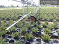
Another watering device. In the background you can make out the tower of Nuremberg's airport. @49.5032,11.0506
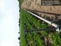
This watering device is located right at the hashpoint. @49.5125,11.0433


Achievements