Difference between revisions of "2015-07-17 49 11"
From Geohashing
imported>Schnatterfleck (Small rainbow (lower left) and asparagus field (also left) [http://www.openstreetmap.org/?lat=49.47760000&lon=11.04460000&zoom=16&layers=B000FTF @49.4776,11.0446]) |
imported>Schnatterfleck |
||
| Line 20: | Line 20: | ||
== Location == | == Location == | ||
<!-- where you've surveyed the hash to be --> | <!-- where you've surveyed the hash to be --> | ||
| + | The watering pipeline in a field of celery near Kraftshof. | ||
== Participants == | == Participants == | ||
<!-- who attended: If you link to your wiki user name in this section, your expedition will be picked up by the various statistics generated for geohashing. You may use three tildes ~ as a shortcut to automatically insert the user signature of the account you are editing with. | <!-- who attended: If you link to your wiki user name in this section, your expedition will be picked up by the various statistics generated for geohashing. You may use three tildes ~ as a shortcut to automatically insert the user signature of the account you are editing with. | ||
--> | --> | ||
| + | [[User:Schnatterfleck|Schnatterfleck]] ([[User talk:Schnatterfleck|talk]]) | ||
== Plans == | == Plans == | ||
Revision as of 14:06, 17 July 2015
| Fri 17 Jul 2015 in 49,11: 49.5124496, 11.0433368 geohashing.info google osm bing/os kml crox |
Location
The watering pipeline in a field of celery near Kraftshof.
Participants
Plans
Expedition
Tracklog
Photos
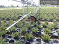
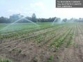
Massively parallel automated plant pot watering @49.5014,11.0523
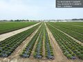
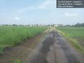
Enough little patio greenery for the better part of southern Germany @49.5032,11.0508
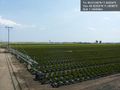
Another watering device. In the background you can make out the tower of Nuremberg's airport. @49.5032,11.0506
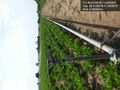
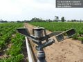
This watering device is located right at the hashpoint. @49.5125,11.0433
Interesting construction... @49.5125,11.0433
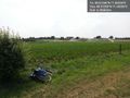
Bike near hashpoint. Artificial rain in the background. @49.5125,11.0433
Finally getting really wet :-) @49.4775,11.0447
Small rainbow (lower left) and asparagus field (also left) @49.4776,11.0446


Achievements