Difference between revisions of "2015-08-16 -12 130"
imported>Felix Dance (Felix & Lucy at the geohash. [http://www.openstreetmap.org/?lat=-12.49491601&lon=130.96827536&zoom=16&layers=B000FTF @-12.4949,130.9683]) |
imported>Felix Dance (Added expedition) |
||
| Line 20: | Line 20: | ||
== Location == | == Location == | ||
<!-- where you've surveyed the hash to be --> | <!-- where you've surveyed the hash to be --> | ||
| + | Just off a main road in Palmerston. | ||
== Participants == | == Participants == | ||
| − | + | *[[User:Felix Dance|Felix]] | |
| − | + | *Lucy | |
| − | |||
| − | |||
| − | |||
== Expedition == | == Expedition == | ||
<!-- how it all turned out. your narrative goes here. --> | <!-- how it all turned out. your narrative goes here. --> | ||
| + | I saw this geohash on Sunday morning, after I'd already decided to go for a bike ride. It transpired that the geohash was actually right on the very route I was planning to take - to Channel Island in Darwin Harbour. | ||
| + | |||
| + | Spending about 2 hours getting my shit together for my ride, off I went towards the hash. A bit over an hour later I was there, and proceeded to spend about 30 minutes frigging around with my various phones and GPSes trying to get a good reading. Soon I started running out of batteries in all devices and I abandoned exactitude in order to complete the ride. Channel Island was a pretty cool destination, 50kms from the Darwin CBD with views across the whole harbour. It's connected by a long road bridge to the mainland. | ||
| + | |||
| + | On my way return, I popped in to visit my friend Lucy, who'd just finished her own epic bike ride. Together, with her dog Pinto, we went back to the hash to get more precision. We had dinner and I rode home, returning home at 10pm. | ||
== Tracklog == | == Tracklog == | ||
| − | + | [https://goo.gl/maps/XiypB Here] is the route I took. | |
== Photos == | == Photos == | ||
| Line 46: | Line 49: | ||
== Achievements == | == Achievements == | ||
| − | {{ | + | {{bicycle geohash |
| − | |||
| − | |||
| − | |||
| − | |||
| − | |||
| − | |||
| − | |||
| − | |||
| − | |||
| − | |||
| − | |||
| − | |||
| − | |||
| − | |||
| − | |||
| − | |||
| − | |||
| − | |||
| − | |||
| − | |||
| − | |||
| − | |||
| − | |||
| − | |||
| − | |||
| − | |||
| − | |||
| − | |||
| − | |||
| − | |||
| − | |||
| − | |||
| − | |||
| − | + | | latitude = -12 | |
| − | [[ | + | | longitude = 130 |
| − | + | | date = 2015-08-16 | |
| − | + | | name = [[User:Felix Dance|Felix Dance]] | |
| − | + | | distance = 99.3kms | |
| + | | bothways = true | ||
| + | | image = 2015-08-16_-12_130_Felix Dance_1439694620019.jpg | ||
| − | + | }} | |
Revision as of 03:46, 17 August 2015
| Sun 16 Aug 2015 in -12,130: -12.4949137, 130.9682920 geohashing.info google osm bing/os kml crox |
Location
Just off a main road in Palmerston.
Participants
- Felix
- Lucy
Expedition
I saw this geohash on Sunday morning, after I'd already decided to go for a bike ride. It transpired that the geohash was actually right on the very route I was planning to take - to Channel Island in Darwin Harbour.
Spending about 2 hours getting my shit together for my ride, off I went towards the hash. A bit over an hour later I was there, and proceeded to spend about 30 minutes frigging around with my various phones and GPSes trying to get a good reading. Soon I started running out of batteries in all devices and I abandoned exactitude in order to complete the ride. Channel Island was a pretty cool destination, 50kms from the Darwin CBD with views across the whole harbour. It's connected by a long road bridge to the mainland.
On my way return, I popped in to visit my friend Lucy, who'd just finished her own epic bike ride. Together, with her dog Pinto, we went back to the hash to get more precision. We had dinner and I rode home, returning home at 10pm.
Tracklog
Here is the route I took.
Photos
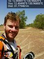
Geohash success - Palmerston @-12.4949,130.9680
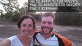
Felix & Lucy at the geohash. @-12.4949,130.9683


Achievements
Felix Dance earned the Bicycle geohash achievement
|