Difference between revisions of "2015-10-22 52 9"
imported>GlobeCacher.de (→Photos) |
imported>GlobeCacher.de (→Photos) |
||
| Line 36: | Line 36: | ||
Image:2015-10-22_17.13.37.png | Hit the spot (on the iPhone App) | Image:2015-10-22_17.13.37.png | Hit the spot (on the iPhone App) | ||
Image:2015-10-22 52 9 01.jpg | Hit the spot (Garmin) | Image:2015-10-22 52 9 01.jpg | Hit the spot (Garmin) | ||
| − | + | Image:2015-10-22-52-9-GlobeCacher.JPG | Me & Luna at the spot (we hate selfies ...) | |
| − | 2015-10-22_17.14.22.jpg | View north (east, west and south look very similar ...) | + | Image:2015-10-22_17.14.22.jpg | View north (east, west and south look very similar ...) |
</gallery> | </gallery> | ||
Revision as of 17:02, 22 October 2015
| Thu 22 Oct 2015 in 52,9: 52.2264413, 9.9058017 geohashing.info google osm bing/os kml crox |
Location
A waste acre between Sarstedt and Klein Förste
Participants
GlobeCacher & cachedog Luna
Expedition
After having watched the meetup coordinates for my graticule(s) for a few weeks, I finally found a location that could easily be reached and is only a mile away from my home coords. So I grabbed my dog Luna (who always loves to accompany me during my geocaching trips) and took a walk to the location. Arriving at the spot, I happily noticed that the acre had already been harvested (the farmer wouldn't have been glad about a geohasher walking through his corn field ...), so I could approach the final destination while cross-checking between Garmin and smartphone. Now I've made my first expedition and am happy to announce it, although the spot was very unimpressive (you could also call it boring).
Photos
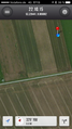
Hit the spot (on the iPhone App)
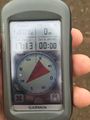
Hit the spot (Garmin)
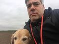
Me & Luna at the spot (we hate selfies ...)
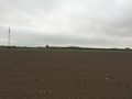
View north (east, west and south look very similar ...)


Achievements