Difference between revisions of "2015-10-24 49 -123"
imported>Rhonda (filling in the report) |
imported>Rhonda (Success :)) |
||
| Line 29: | Line 29: | ||
== Expedition == | == Expedition == | ||
<!-- how it all turned out. your narrative goes here. --> | <!-- how it all turned out. your narrative goes here. --> | ||
| − | + | The simplest execution of a geohash... I programmed the coordinates into my running GPS, then Sophie and I went for a run up Mosquito Creek. Between the navigation arrow and my memory of what the map looked like, I ran directly to the point then chalked the pavement and took a couple of pictures, after which I ran back to the park and a little further upstream before turning around and running home. | |
| − | |||
| − | |||
== Photos == | == Photos == | ||
| Line 38: | Line 36: | ||
--> | --> | ||
<gallery> | <gallery> | ||
| + | Image:2015-10-24 49 -123 trail.JPG | Heading up Mosquito Creek park | ||
| + | Image:2015-10-24 49 -123 under bridge.JPG | and under the highway bridge | ||
| + | Image:2015-10-24 49 -123 gps.JPG | to the hashpoint, | ||
| + | Image:2015-10-24 49 -123 grin.JPG | a silly grin, | ||
| + | Image:2015-10-24 49 -123 sophie chalk.JPG | and some chalk marks. | ||
| + | Image:2015-10-24 49 -123 creek.JPG | Then another picture of the park on the way back down, just because I live in a beautiful area. | ||
</gallery> | </gallery> | ||
| Line 43: | Line 47: | ||
{{#vardefine:ribbonwidth|800px}} | {{#vardefine:ribbonwidth|800px}} | ||
<!-- Add any achievement ribbons you earned below, or remove this section --> | <!-- Add any achievement ribbons you earned below, or remove this section --> | ||
| + | {{Walk geohash | ||
| + | | latitude = 49 | ||
| + | | longitude = -123 | ||
| + | | date = 2015-10-24 | ||
| + | | name = Rhonda | ||
| + | | distance = 8km | ||
| + | | image = | ||
| + | }} | ||
<!-- =============== USEFUL CATEGORIES FOLLOW ================ | <!-- =============== USEFUL CATEGORIES FOLLOW ================ | ||
| − | |||
| − | |||
| − | |||
| − | |||
| − | |||
| − | |||
| − | |||
| − | |||
[[Category:Expeditions]] | [[Category:Expeditions]] | ||
| − | |||
[[Category:Expeditions with photos]] | [[Category:Expeditions with photos]] | ||
| − | |||
| − | |||
| − | |||
| − | |||
| − | |||
[[Category:Coordinates reached]] | [[Category:Coordinates reached]] | ||
| − | |||
| − | |||
| − | |||
| − | |||
| − | |||
| − | |||
| − | |||
| − | |||
| − | |||
| − | |||
| − | |||
| − | |||
| − | |||
| − | |||
| − | |||
| − | |||
| − | |||
| − | |||
Revision as of 01:11, 25 October 2015
| Sat 24 Oct 2015 in 49,-123: 49.3388878, -123.0897548 geohashing.info google osm bing/os kml crox |
Location
On a street in North Vancouver, near the north end of the Mosquito Creek trail.
Participants
Plans
Walk up the Mosquito Creek trail, then walk back down it. If nobody joins me I might run it instead. It looks to be about an hour's walk to the hashpoint from the Seabus Terminal.
Expedition
The simplest execution of a geohash... I programmed the coordinates into my running GPS, then Sophie and I went for a run up Mosquito Creek. Between the navigation arrow and my memory of what the map looked like, I ran directly to the point then chalked the pavement and took a couple of pictures, after which I ran back to the park and a little further upstream before turning around and running home.
Photos
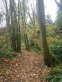
Heading up Mosquito Creek park
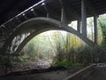
and under the highway bridge
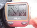
to the hashpoint,
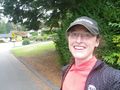
a silly grin,
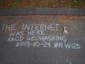
and some chalk marks.
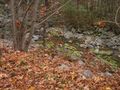
Then another picture of the park on the way back down, just because I live in a beautiful area.


Achievements
Rhonda earned the Walk geohash Achievement
|