Difference between revisions of "2016-04-09 -37 145"
imported>Kozz ([live picture]Hash point) |
imported>Kozz ([live picture]Distant view (ironbark road)) |
||
| Line 51: | Line 51: | ||
Image:2016-04-09_-37_145_kozz_1460165942769.jpg|Hash point | Image:2016-04-09_-37_145_kozz_1460165942769.jpg|Hash point | ||
| + | |||
| + | Image:2016-04-09_-37_145_kozz_1460166151368.jpg|Distant view (ironbark road) | ||
</gallery> | </gallery> | ||
Revision as of 01:42, 9 April 2016
| Sat 9 Apr 2016 in -37,145: -37.6579399, 145.1496916 geohashing.info google osm bing/os kml crox |
Location
Private property, farm, back of diamond Creek Kozz (talk) 22:18, 8 April 2016 (UTC)
Participants
Plans
5am start, cycle out up through Eltham then diamond Creek to ironbark road
Expedition
Yeah bitches, Melbourne East is back! It's the only time in the past week where the hash is within striking distance.
So yeah, it's been a while. the 2016 model of Kozz is the MAMIL variant, hence looking for opportunities to cycle places. This looked ok and all was well and good till the turnoff onto the access road which quickly became steep gravel - great news on a road bike and 23c tyres.
The spot is up a steep hill off the road on private property, it wasn't worth the schlep to the hash point so snapped a picture and some positional stuff and off we go.
Oh, and for those who remember my previous hashes. I'm sorry to say Kozz's Dog passed away a while ago, poor bugger. He will live on in this wiki through his achievements. Kozz (talk) 22:27, 8 April 2016 (UTC)
Tracklog
Photos
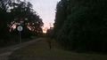
Sunrise
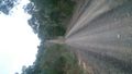
The hill
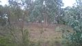
Hash point
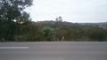
Distant view (ironbark road)


Achievements