Difference between revisions of "2016-04-30 34 -117"
From Geohashing
imported>AeroIllini (An expedition message sent via Geohash Droid for Android.) |
imported>AeroIllini ([live picture]Standing on the spot! Just a few hundred feet outside the fence line of Southern California Logistics Airport in Victorville. [http://www.openstreetmap.org/?lat=34.62325660&lon=-117.37955600&zoom=16&layers=B000FTF @34.6233,-117.3796]) |
||
| Line 39: | Line 39: | ||
--> | --> | ||
<gallery perrow="5"> | <gallery perrow="5"> | ||
| + | |||
| + | Image:2016-04-30_34_-117_AeroIllini_1462045990095.jpg|Standing on the spot! Just a few hundred feet outside the fence line of Southern California Logistics Airport in Victorville. [http://www.openstreetmap.org/?lat=34.62325660&lon=-117.37955600&zoom=16&layers=B000FTF @34.6233,-117.3796] | ||
</gallery> | </gallery> | ||
Revision as of 19:53, 30 April 2016
| Sat 30 Apr 2016 in 34,-117: 34.6232513, -117.3795681 geohashing.info google osm bing/os kml crox |
Location
Participants
Plans
Expedition
Tracklog
Photos
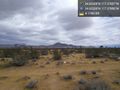
Standing on the spot! Just a few hundred feet outside the fence line of Southern California Logistics Airport in Victorville. @34.6233,-117.3796

Achievements