Difference between revisions of "2016-04-30 34 -117"
From Geohashing
imported>AeroIllini ([live picture]Standing on the spot! Just a few hundred feet outside the fence line of Southern California Logistics Airport in Victorville. [http://www.openstreetmap.org/?lat=34.62325660&lon=-117.37955600&zoom=16&layers=B000FTF @34.6233,-117.3796]) |
imported>AeroIllini (→Location) |
||
| Line 20: | Line 20: | ||
== Location == | == Location == | ||
<!-- where you've surveyed the hash to be --> | <!-- where you've surveyed the hash to be --> | ||
| + | In the desert just to the east of the fence line of the Southern California Logistics Airport in Victorville, CA. | ||
== Participants == | == Participants == | ||
Revision as of 21:20, 30 April 2016
| Sat 30 Apr 2016 in 34,-117: 34.6232513, -117.3795681 geohashing.info google osm bing/os kml crox |
Location
In the desert just to the east of the fence line of the Southern California Logistics Airport in Victorville, CA.
Participants
Plans
Expedition
Tracklog
Photos
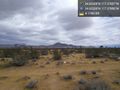
Standing on the spot! Just a few hundred feet outside the fence line of Southern California Logistics Airport in Victorville. @34.6233,-117.3796

Achievements