Difference between revisions of "2016-04-30 34 -117"
imported>AeroIllini ([live picture]A bridge over a trench.) |
imported>AeroIllini (→Expedition) |
||
| Line 36: | Line 36: | ||
Travel method was via rental car on roads around the airport that became increasingly less paved with proximity to the point, and then by foot in the last 1000 feet or so. | Travel method was via rental car on roads around the airport that became increasingly less paved with proximity to the point, and then by foot in the last 1000 feet or so. | ||
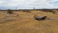
| − | In the area, a | + | In the area, a line of tires was found, as well as a wooden structure, a fire pit shielded by a wall of tires, and some other evidence of human activity. |
== Tracklog == | == Tracklog == | ||
Revision as of 22:04, 30 April 2016
| Sat 30 Apr 2016 in 34,-117: 34.6232513, -117.3795681 geohashing.info google osm bing/os kml crox |
Location
In the desert just to the east of the fence line of the Southern California Logistics Airport in Victorville, CA.
Participants
Plans
Expedition
AeroIllini, while visiting from Seattle, stopped by the point in the early afternoon to snap a few photos.
Travel method was via rental car on roads around the airport that became increasingly less paved with proximity to the point, and then by foot in the last 1000 feet or so.
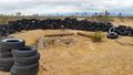
In the area, a line of tires was found, as well as a wooden structure, a fire pit shielded by a wall of tires, and some other evidence of human activity.
Tracklog
Photos
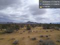
Standing on the spot! Just a few hundred feet outside the fence line of Southern California Logistics Airport in Victorville. @34.6233,-117.3796
Found a curious line of tires out in the desert.
A tire-shielded fire pit.
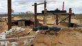
Wooden structure
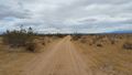
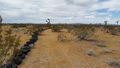
The road, leading toward KVCV airport.
A bridge over a trench.


Achievements