Difference between revisions of "2016-05-01 34 -117"
From Geohashing
imported>AeroIllini (Some of the surrounding countryside. [http://www.openstreetmap.org/?lat=34.75659300&lon=-117.15616880&zoom=16&layers=B000FTF @34.7566,-117.1562]) |
imported>AeroIllini (→Location) |
||
| Line 20: | Line 20: | ||
== Location == | == Location == | ||
<!-- where you've surveyed the hash to be --> | <!-- where you've surveyed the hash to be --> | ||
| + | The point is in the Stoddard Valley Off-Highway Vehicle Recreation Area, beside I-15 between Victorville and Barstow. | ||
== Participants == | == Participants == | ||
Revision as of 18:31, 1 May 2016
| Sun 1 May 2016 in 34,-117: 34.7565890, -117.1561773 geohashing.info google osm bing/os kml crox |
Location
The point is in the Stoddard Valley Off-Highway Vehicle Recreation Area, beside I-15 between Victorville and Barstow.
Participants
Plans
Expedition
Tracklog
Photos

Success! @34.7566,-117.1562
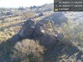
This pile of rocks marks the spot. @34.7566,-117.1562
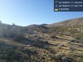
Some of the surrounding countryside. @34.7566,-117.1562


Achievements