Difference between revisions of "2016-05-01 34 -117"
From Geohashing
imported>AeroIllini (→Location) |
imported>AeroIllini (→Participants) |
||
| Line 25: | Line 25: | ||
<!-- who attended: If you link to your wiki user name in this section, your expedition will be picked up by the various statistics generated for geohashing. You may use three tildes ~ as a shortcut to automatically insert the user signature of the account you are editing with. | <!-- who attended: If you link to your wiki user name in this section, your expedition will be picked up by the various statistics generated for geohashing. You may use three tildes ~ as a shortcut to automatically insert the user signature of the account you are editing with. | ||
--> | --> | ||
| + | [[User:AeroIllini|AeroIllini]], visiting from Seattle. | ||
== Plans == | == Plans == | ||
Revision as of 18:32, 1 May 2016
| Sun 1 May 2016 in 34,-117: 34.7565890, -117.1561773 geohashing.info google osm bing/os kml crox |
Location
The point is in the Stoddard Valley Off-Highway Vehicle Recreation Area, beside I-15 between Victorville and Barstow.
Participants
AeroIllini, visiting from Seattle.
Plans
Expedition
Tracklog
Photos

Success! @34.7566,-117.1562
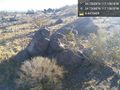
This pile of rocks marks the spot. @34.7566,-117.1562
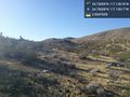
Some of the surrounding countryside. @34.7566,-117.1562


Achievements