Difference between revisions of "2016-05-01 34 -116"
From Geohashing
imported>AeroIllini (Looking west. [http://www.openstreetmap.org/?lat=34.75659610&lon=-116.15618470&zoom=16&layers=B000FTF @34.7566,-116.1562]) |
imported>AeroIllini (→Location) |
||
| Line 20: | Line 20: | ||
== Location == | == Location == | ||
<!-- where you've surveyed the hash to be --> | <!-- where you've surveyed the hash to be --> | ||
| + | The point is under some high-voltage wires a mile or so north of Ludlow, CA. | ||
== Participants == | == Participants == | ||
Revision as of 18:49, 1 May 2016
| Sun 1 May 2016 in 34,-116: 34.7565890, -116.1561773 geohashing.info google osm bing/os kml crox |
Location
The point is under some high-voltage wires a mile or so north of Ludlow, CA.
Participants
Plans
Expedition
Tracklog
Photos

Success! @34.7566,-116.1562
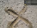
X marks the spot. @34.7566,-116.1562
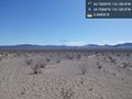
Some of the surrounding countryside, with high voltage power lines buzzing overhead. @34.7566,-116.1562
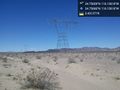
Looking west. @34.7566,-116.1562


Achievements