Difference between revisions of "2016-05-21 34 -117"
From Geohashing
imported>AeroIllini ([live picture]The building was closed. This is as close as I got. [http://www.openstreetmap.org/?lat=34.03617590&lon=-117.61573540&zoom=16&layers=B000FTF @34.0362,-117.6157]) |
imported>AeroIllini ([live picture]The warehouse. [http://www.openstreetmap.org/?lat=34.03616260&lon=-117.61573360&zoom=16&layers=B000FTF @34.0362,-117.6157]) |
||
| Line 41: | Line 41: | ||
Image:2016-05-21_34_-117_AeroIllini_1463865867102.jpg|The building was closed. This is as close as I got. [http://www.openstreetmap.org/?lat=34.03617590&lon=-117.61573540&zoom=16&layers=B000FTF @34.0362,-117.6157] | Image:2016-05-21_34_-117_AeroIllini_1463865867102.jpg|The building was closed. This is as close as I got. [http://www.openstreetmap.org/?lat=34.03617590&lon=-117.61573540&zoom=16&layers=B000FTF @34.0362,-117.6157] | ||
| + | |||
| + | Image:2016-05-21_34_-117_AeroIllini_1463865899985.jpg|The warehouse. [http://www.openstreetmap.org/?lat=34.03616260&lon=-117.61573360&zoom=16&layers=B000FTF @34.0362,-117.6157] | ||
</gallery> | </gallery> | ||
Revision as of 21:25, 21 May 2016
| Sat 21 May 2016 in 34,-117: 34.0365641, -117.6168378 geohashing.info google osm bing/os kml crox |
Location
Participants
Plans
Expedition
Tracklog
Photos

The building was closed. This is as close as I got. @34.0362,-117.6157
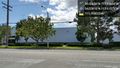
The warehouse. @34.0362,-117.6157


Achievements