Difference between revisions of "2016-05-21 34 -117"
From Geohashing
imported>AeroIllini (An expedition message sent via Geohash Droid for Android.) |
imported>FippeBot m (Location) |
||
| (9 intermediate revisions by 2 users not shown) | |||
| Line 20: | Line 20: | ||
== Location == | == Location == | ||
<!-- where you've surveyed the hash to be --> | <!-- where you've surveyed the hash to be --> | ||
| + | A warehouse south of LA/Ontario airport. | ||
== Participants == | == Participants == | ||
<!-- who attended: If you link to your wiki user name in this section, your expedition will be picked up by the various statistics generated for geohashing. You may use three tildes ~ as a shortcut to automatically insert the user signature of the account you are editing with. | <!-- who attended: If you link to your wiki user name in this section, your expedition will be picked up by the various statistics generated for geohashing. You may use three tildes ~ as a shortcut to automatically insert the user signature of the account you are editing with. | ||
--> | --> | ||
| + | * [[User:AeroIllini|AeroIllini]] (visiting from [[47,-122|Seattle]]) | ||
== Plans == | == Plans == | ||
| Line 30: | Line 32: | ||
== Expedition == | == Expedition == | ||
<!-- how it all turned out. your narrative goes here. --> | <!-- how it all turned out. your narrative goes here. --> | ||
| + | [[User:AeroIllini|AeroIllini]] made an attempt to reach the point on a sunny Saturday afternoon before his flight for Seattle left out of LA/Ontario. A quick trip around the block confirmed that the point was indeed inside the warehouse, which was closed for the weekend. Closest approach was approximately 110m. | ||
== Tracklog == | == Tracklog == | ||
| Line 39: | Line 42: | ||
--> | --> | ||
<gallery perrow="5"> | <gallery perrow="5"> | ||
| + | |||
| + | Image:2016-05-21_34_-117_AeroIllini_1463865867102.jpg|The building was closed. This is as close as I got. [http://www.openstreetmap.org/?lat=34.03617590&lon=-117.61573540&zoom=16&layers=B000FTF @34.0362,-117.6157] | ||
| + | |||
| + | Image:2016-05-21_34_-117_AeroIllini_1463865899985.jpg|The warehouse. [http://www.openstreetmap.org/?lat=34.03616260&lon=-117.61573360&zoom=16&layers=B000FTF @34.0362,-117.6157] | ||
</gallery> | </gallery> | ||
| Line 47: | Line 54: | ||
<!-- =============== USEFUL CATEGORIES FOLLOW ================ | <!-- =============== USEFUL CATEGORIES FOLLOW ================ | ||
Delete the next line ONLY if you have chosen the appropriate categories below. If you are unsure, don't worry. People will read your report and help you with the classification. --> | Delete the next line ONLY if you have chosen the appropriate categories below. If you are unsure, don't worry. People will read your report and help you with the classification. --> | ||
| − | |||
| − | |||
| − | |||
| − | |||
| − | |||
| − | |||
| − | |||
| − | |||
| − | |||
[[Category:Expeditions]] | [[Category:Expeditions]] | ||
| − | |||
[[Category:Expeditions with photos]] | [[Category:Expeditions with photos]] | ||
| − | |||
| − | |||
| − | |||
| − | |||
| − | |||
| − | |||
| − | |||
| − | |||
| − | |||
[[Category:Coordinates not reached]] | [[Category:Coordinates not reached]] | ||
| − | |||
| − | |||
| − | |||
| − | |||
| − | |||
[[Category:Not reached - No public access]] | [[Category:Not reached - No public access]] | ||
| − | + | {{location|US|CA|SA}} | |
| − | |||
| − | |||
| − | |||
| − | |||
| − | |||
| − | |||
| − | |||
Latest revision as of 01:50, 7 August 2019
| Sat 21 May 2016 in 34,-117: 34.0365641, -117.6168378 geohashing.info google osm bing/os kml crox |
Location
A warehouse south of LA/Ontario airport.
Participants
- AeroIllini (visiting from Seattle)
Plans
Expedition
AeroIllini made an attempt to reach the point on a sunny Saturday afternoon before his flight for Seattle left out of LA/Ontario. A quick trip around the block confirmed that the point was indeed inside the warehouse, which was closed for the weekend. Closest approach was approximately 110m.
Tracklog
Photos
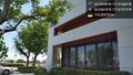
The building was closed. This is as close as I got. @34.0362,-117.6157
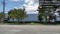
The warehouse. @34.0362,-117.6157

