Difference between revisions of "2016-06-19 38 -77"
From Geohashing
imported>Fillmore ([live picture]Sidewalk in Cleveland Park, D.C., just off Wisconsin Avenue. [http://www.openstreetmap.org/?lat=38.93561040&lon=-77.07224750&zoom=16&layers=B000FTF @38.9356,-77.0722]) |
imported>Fillmore |
||
| Line 19: | Line 19: | ||
== Location == | == Location == | ||
| − | + | Sidewalk in Cleveland Park, D.C., just off Wisconsin Avenue. | |
== Participants == | == Participants == | ||
| − | + | *[[User:Fillmore|Fillmore]] | |
| − | |||
== Plans == | == Plans == | ||
| − | + | A longtime xkcd fan, I downloaded the geohashing app for kicks a few weeks ago. When I saw this Sunday's point would be less than 1.5 miles from where I live in D.C., there was no excuse not to score my first hash. | |
== Expedition == | == Expedition == | ||
| − | + | Hopped the #96 bus. (Didn't think to get a picture of the bus, sadly. Next time...) Got off at Wisconsin and Newark and walked less than 5 minutes. Hashpoint was right on the sidewalk. Celebrated with enchiladas at the nearby [http://www.cactuscantina.com/ Cactus Cantina]. | |
== Tracklog == | == Tracklog == | ||
| Line 40: | Line 39: | ||
<gallery perrow="5"> | <gallery perrow="5"> | ||
| − | Image:2016-06-19_38_-77_Fillmore_1466383513595.jpg| | + | Image:2016-06-19_38_-77_Fillmore_1466383513595.jpg|The hashpoint. [http://www.openstreetmap.org/?lat=38.93561040&lon=-77.07224750&zoom=16&layers=B000FTF @38.9356,-77.0722] |
</gallery> | </gallery> | ||
| Line 46: | Line 45: | ||
{{#vardefine:ribbonwidth|800px}} | {{#vardefine:ribbonwidth|800px}} | ||
<!-- Add any achievement ribbons you earned below, or remove this section --> | <!-- Add any achievement ribbons you earned below, or remove this section --> | ||
| + | |||
| + | {{land geohash | ||
| + | | latitude = 38 | ||
| + | | longitude = -77 | ||
| + | | date = 2016-06-19 | ||
| + | | name = Fillmore | ||
| + | }} | ||
| + | {{Public transport geohash | ||
| + | | latitude = 38 | ||
| + | | longitude = -77 | ||
| + | | date = 2016-06-19 | ||
| + | | name = Fillmore | ||
| + | }} | ||
<!-- =============== USEFUL CATEGORIES FOLLOW ================ | <!-- =============== USEFUL CATEGORIES FOLLOW ================ | ||
Revision as of 02:56, 21 June 2016
| Sun 19 Jun 2016 in 38,-77: 38.9355965, -77.0722268 geohashing.info google osm bing/os kml crox |
Location
Sidewalk in Cleveland Park, D.C., just off Wisconsin Avenue.
Participants
Plans
A longtime xkcd fan, I downloaded the geohashing app for kicks a few weeks ago. When I saw this Sunday's point would be less than 1.5 miles from where I live in D.C., there was no excuse not to score my first hash.
Expedition
Hopped the #96 bus. (Didn't think to get a picture of the bus, sadly. Next time...) Got off at Wisconsin and Newark and walked less than 5 minutes. Hashpoint was right on the sidewalk. Celebrated with enchiladas at the nearby Cactus Cantina.
Tracklog
Photos
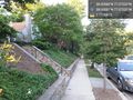
The hashpoint. @38.9356,-77.0722

Achievements
Fillmore earned the Land geohash achievement
|
Fillmore earned the Public transport geohash achievement
|