Difference between revisions of "2016-12-28 38 -122"
imported>Coyotebush ([retro picture]Closest approach) |
imported>Blueberrynewt (→Photos) |
||
| Line 37: | Line 37: | ||
Image:2012-##-## ## ## Alpha.jpg | Witty Comment | Image:2012-##-## ## ## Alpha.jpg | Witty Comment | ||
--> | --> | ||
| − | <gallery perrow=" | + | <gallery perrow="4"> |
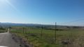
Image:2016-12-28 38 -122 1.jpg | the hashpoint is out there somewhere | Image:2016-12-28 38 -122 1.jpg | the hashpoint is out there somewhere | ||
Image:2016-12-28 38 -122 3.jpg | here is the fence in question | Image:2016-12-28 38 -122 3.jpg | here is the fence in question | ||
Revision as of 21:45, 30 December 2016
| Wed 28 Dec 2016 in 38,-122: 38.2722309, -122.5788211 geohashing.info google osm bing/os kml crox |
Location
In a fenced cow pasture outside of Petaluma.
Participants
Plans
Head over sometime after lunch. The nearby road looks easily reachable, but satellite images suggest a fence.
Expedition
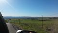
It was a clear, sunny day. Aside from a wrong turn followed by a small dog blocking traffic in Penngrove, we arrived mostly uneventfully at the low point of Manor Ln shortly before 13:40. There were indeed fences along both sides of the road, so rather than cross them to reach the hashpoint we instead stopped the car and walked to the closest accessible point. Unfortunately, that was still about 72m from the hashpoint. Photos were taken anyway, and the view on the way back down the hill was enjoyed.
Photos
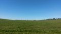
the hashpoint is out there somewhere
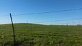
here is the fence in question
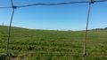
fence closeup
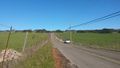
view up the road
view from the top of the road
from the top of the road again
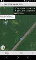
Closest approach


