Difference between revisions of "2017-01-01 53 -2"
From Geohashing
imported>Angel ([live picture]About as close as we can get :)) |
imported>Angel ([live picture]Right here… that was an easy one! [http://www.openstreetmap.org/?lat=53.43355230&lon=-2.79344110&zoom=16&layers=B000FTF @53.4336,-2.7934]) |
||
| Line 43: | Line 43: | ||
Image:2017-01-01_53_-2_Angel_1483281771006.jpg|About as close as we can get :) | Image:2017-01-01_53_-2_Angel_1483281771006.jpg|About as close as we can get :) | ||
| + | |||
| + | Image:2017-01-01_53_-2_Angel_1483281821262.jpg|Right here… that was an easy one! [http://www.openstreetmap.org/?lat=53.43355230&lon=-2.79344110&zoom=16&layers=B000FTF @53.4336,-2.7934] | ||
</gallery> | </gallery> | ||
Revision as of 14:43, 1 January 2017
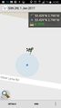
| Sun 1 Jan 2017 in 53,-2: 53.4286439, -2.7963389 geohashing.info google osm bing/os kml crox |
Location
Participants
Plans
Expedition
- This looks pretty close; close enough to head that way and see if its accessible rather than sscrutinising the map. -- Angel (talk) @53.4978,-2.7450 14:25, 1 January 2017 (GMT+00:00)
Tracklog
Photos
About as close as we can get :)
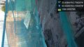
Right here… that was an easy one! @53.4336,-2.7934


Achievements