Difference between revisions of "2017-02-14 -37 145"
From Geohashing
imported>Kozz ([retro picture]Hash point approach hill) |
imported>Kozz ([retro picture]The hashpoint (potato quality)) |
||
| Line 47: | Line 47: | ||
Image:2017-02-14_-37_145_kozz_1487394618834.jpg|Hash point approach hill | Image:2017-02-14_-37_145_kozz_1487394618834.jpg|Hash point approach hill | ||
| + | |||
| + | Image:2017-02-14_-37_145_kozz_1487394662214.jpg|The hashpoint (potato quality) | ||
</gallery> | </gallery> | ||
Revision as of 05:11, 18 February 2017
| Tue 14 Feb 2017 in -37,145: -37.8491212, 145.4526681 geohashing.info google osm bing/os kml crox |
Location
Participants
Plans
Expedition
- I'm planning on doing a dawn ride put to this on Saturday weather depending. Know exactly where it is. -- Kozz (talk) 19:57, 15 February 2017 (GMT+11:00)
Tracklog
Photos
I made it!

En route

Hash point approach hill
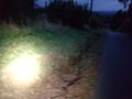
The hashpoint (potato quality)


Achievements