Difference between revisions of "2017-03-15 49 8"
From Geohashing
imported>DODO |
imported>DODO (→Achievements) |
||
| Line 53: | Line 53: | ||
<!-- Add any achievement ribbons you earned below, or remove this section --> | <!-- Add any achievement ribbons you earned below, or remove this section --> | ||
| − | + | ||
{{OpenStreetMap achievement | {{OpenStreetMap achievement | ||
| latitude = 49 | | latitude = 49 | ||
| Line 65: | Line 65: | ||
| latitude = 49 | | latitude = 49 | ||
| longitude = 8 | | longitude = 8 | ||
| − | | date = | + | | date = 2017-03-15 |
| name = DODO | | name = DODO | ||
| − | | distance = | + | | distance = 17m |
}} | }} | ||
Revision as of 19:28, 17 March 2017
| Wed 15 Mar 2017 in 49,8: 49.3915635, 8.3954586 geohashing.info google osm bing/os kml crox |
Location
In a nurserynext to Schifferstadt
Participants
Plans
Go there by bull on my way to the office.
Expedition
I haven't been hashing for a while and when I saw this hash so close to home I couldn't resist although it was probably posted. Well, things went pretty much as planned: I came close to the hash, but a fence stopped me 17 m before I reached my aim. I took some pictures and continued my way to the office, using the ferry in Altrip once again. There was a path behind the nursery that I just added on OSM.
Tracklog
Photos
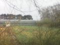
17 m to go. The fence and the nursery.

bull next to the fence

unhappy hasher
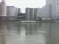
ferry

proof of failure


Achievements
DODO earned the OpenStreetMap achievement
|
DODO earned the No trespassing consolation prize
|