Difference between revisions of "2017-07-08 60 24"
From Geohashing
imported>PPP (Blanked the page) |
imported>PPP |
||
| Line 1: | Line 1: | ||
| + | <!-- If you did not specify these parameters in the template, please substitute appropriate values for IMAGE, LAT, LON, and DATE (YYYY-MM-DD format) | ||
| + | |||
| + | [[Image:{{{image|IMAGE}}}|thumb|left]] | ||
| + | |||
| + | Remove this section if you don't want an image at the top (left) of your report. You should remove the "Image:" or "File:" | ||
| + | tag from your image file name, and replace the all upper-case word IMAGE in the above line. | ||
| + | |||
| + | And DON'T FORGET to add your expedition and the best photo you took to the gallery on the Main Page! We'd love to read your report, but that means we first have to discover it! :) | ||
| + | --> | ||
| + | {{meetup graticule | ||
| + | | lat=60 | ||
| + | | lon=24 | ||
| + | | date=2017-07-08 | ||
| + | }} | ||
| + | |||
| + | <!-- edit as necessary --> | ||
| + | __NOTOC__ | ||
| + | |||
| + | == Location == | ||
| + | Tuusula / Vantaa near the end of Helsinki-Vantaa airpot Runaway in the bushes of the Kratinkallio <!-- where you've surveyed the hash to be --> | ||
| + | |||
| + | == Participants == | ||
| + | <!-- who attended: If you link to your wiki user name in this section, your expedition will be picked up by the various statistics generated for geohashing. You may use three tildes ~ as a shortcut to automatically insert the user signature of the account you are editing with. | ||
| + | --> | ||
| + | [[User:PPP|PPP]] ([[User talk:PPP|talk]]) 15:44, 18 June 2017 (UTC) | ||
| + | |||
| + | == Plans == | ||
| + | <!-- what were the original plans --> | ||
| + | [[User:PPP|PPP]] ([[User talk:PPP|talk]])- Noticed that Saturdays 60 24 will be reachable by bike and the weather according to forecast will be suitable for cycling. | ||
| + | Leaving Helsinki around 17:00 and arriving maybe an hour later, estimated distance is 20-25 km | ||
| + | |||
| + | == Expedition == | ||
| + | <!-- how it all turned out. your narrative goes here. --> | ||
| + | Story to follow | ||
| + | |||
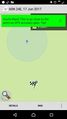
| + | For the final approach I used Geohash Droid and got green well before ~10m of the actual location. Had to do few extra circles to get that close to actual location. | ||
| + | == Tracklog == | ||
| + | <!-- if your GPS device keeps a log, you may post a link here --> | ||
| + | |||
| + | == Photos == | ||
| + | <!-- Insert pictures between the gallery tags using the following format: | ||
| + | Image:2012-##-## ## ## Alpha.jpg | Witty Comment | ||
| + | --> | ||
| + | <gallery perrow="5"> | ||
| + | |||
| + | Image:2017-06-17_60_24_PPP_1497714761142.jpg|TO BE REPLACED with correct Done this - Once again I send this once earlier directly from the location, but it never arrived - strange? This time it hanged in upload | ||
| + | |||
| + | |||
| + | </gallery> | ||
| + | |||
| + | == Achievements == | ||
| + | {{#vardefine:ribbonwidth|800px}} | ||
| + | <!-- Add any achievement ribbons you earned below, or remove this section --> | ||
| + | |||
| + | {{Bicycle geohash | latitude = 60 | longitude = 24 | date = 2017-07-08 | name = PPP | distance = 70 km | bothways = true | image = 2017-06-17 60 24 PPP 3.jpg }} | ||
| + | |||
| + | <!-- =============== USEFUL CATEGORIES FOLLOW ================ | ||
| + | Delete the next line ONLY if you have chosen the appropriate categories below. If you are unsure, don't worry. People will read your report and help you with the classification. --> | ||
| + | [[Category:New report]] | ||
| + | |||
| + | <!-- ==REQUEST FOR TWITTER BOT== Please leave either the New report or the Expedition planning category in as long as you work on it. This helps the twitter bot a lot with announcing the right outcome at the right moment. --> | ||
| + | |||
| + | <!-- Potential categories. Please include all the ones appropriate to your expedition --> | ||
| + | <!-- If this is a planning page: | ||
| + | [[Category:Expedition planning]] | ||
| + | --> | ||
| + | |||
| + | <!-- If all those plans are never acted upon, change [[Category:Expedition planning]] to [[Category:Not reached - Did not attempt]]. --> | ||
| + | |||
| + | <!-- An actual expedition: | ||
| + | [[Category:Expeditions]] | ||
| + | -- and one or more of -- | ||
| + | [[Category:Expeditions with photos]] | ||
| + | [[Category:Expeditions with videos]] | ||
| + | [[Category:Expedition without GPS]] | ||
| + | --> | ||
| + | |||
| + | <!-- if you reached your coords: | ||
| + | [[Category:Coordinates reached]] | ||
| + | |||
| + | |||
| + | --><!-- or if you failed :( | ||
| + | [[Category:Coordinates not reached]] | ||
| + | -- and a reason -- | ||
| + | When there is a natural obstacle between you and the target: | ||
| + | [[Category:Not reached - Mother Nature]] | ||
| + | |||
| + | When there is a man-made obstacle between you and the target: | ||
| + | [[Category:Not reached - No public access]] | ||
| + | |||
| + | When you failed get your GPS, car, bike or such to work: | ||
| + | [[Category:Not reached - Technology]] | ||
| + | |||
| + | When you went to an alternate location instead of the actual geohash: | ||
| + | [[Category:Not reached - Attended alternate location]] | ||
| + | |||
| + | (Don't forget to delete this final close comment marker) --> | ||
Revision as of 11:40, 9 July 2017
| Sat 8 Jul 2017 in 60,24: 60.3493611, 24.9721675 geohashing.info google osm bing/os kml crox |
Location
Tuusula / Vantaa near the end of Helsinki-Vantaa airpot Runaway in the bushes of the Kratinkallio
Participants
PPP (talk) 15:44, 18 June 2017 (UTC)
Plans
PPP (talk)- Noticed that Saturdays 60 24 will be reachable by bike and the weather according to forecast will be suitable for cycling. Leaving Helsinki around 17:00 and arriving maybe an hour later, estimated distance is 20-25 km
Expedition
Story to follow
For the final approach I used Geohash Droid and got green well before ~10m of the actual location. Had to do few extra circles to get that close to actual location.
Tracklog
Photos
TO BE REPLACED with correct Done this - Once again I send this once earlier directly from the location, but it never arrived - strange? This time it hanged in upload

Achievements
PPP earned the Bicycle geohash achievement
|