Difference between revisions of "2018-03-31 49 8"
From Geohashing
imported>DODO (→Tracklog) |
imported>DODO (→Photos) |
||
| Line 45: | Line 45: | ||
--> | --> | ||
<gallery perrow="5"> | <gallery perrow="5"> | ||
| + | Image:2018-03-31_49_8-1.jpg|bull, 25 m apart | ||
| + | Image:2018-03-31_49_8-2.jpg|25 m into this thorny path | ||
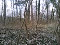
| + | Image:2018-03-31_49_8-7.jpg|proof | ||
| + | Image:2018-03-31_49_8-3.jpg|view to the west | ||
| + | Image:2018-03-31_49_8-4.jpg|to the north (and the path) | ||
| + | Image:2018-03-31_49_8-5.jpg|to the east | ||
| + | Image:2018-03-31_49_8-6.jpg|and to the south (nad the happy hasher) | ||
</gallery> | </gallery> | ||
Revision as of 14:27, 31 March 2018
| Sat 31 Mar 2018 in 49,8: 49.3222345, 8.6667685 geohashing.info google osm bing/os kml crox |
Location
In a small peace of wood south of Sankt Ilgen.
Participants
Plans
Go there by bull in the afternoon. I have to do the shopping first, so I'm not sure, when I can start. Try to be there at hash o'clock. Will start soon (arounf 2 pm) and hope to arrive in an hour.
Expedition
Just a 2 hours ride and a 50 m walk in the warm sunny springtime.
Tracklog
Photos
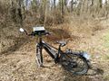
bull, 25 m apart
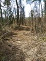
25 m into this thorny path

proof
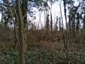
view to the west
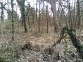
to the north (and the path)
to the east

and to the south (nad the happy hasher)


Achievements