Difference between revisions of "2018-07-15 31 34"
From Geohashing
imported>Dubdub (→Plans) |
imported>Dubdub ([live picture]Tel Aviv bus station) |
||
| Line 43: | Line 43: | ||
--> | --> | ||
<gallery perrow="5"> | <gallery perrow="5"> | ||
| + | |||
| + | Image:2018-07-15_31_34_Dubdub_1531668554826.jpg|Tel Aviv bus station | ||
</gallery> | </gallery> | ||
Revision as of 15:29, 15 July 2018
| Sun 15 Jul 2018 in 31,34: 31.8757748, 34.8170045 geohashing.info google osm bing/os kml crox |
Location
The point fell in the south-most side of Rehovot.
Participants
Plans
The plan was to advance through Tel Aviv to Rehovot using public transport.
Expedition
Tracklog
Photos
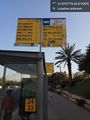
Tel Aviv bus station

Achievements