Difference between revisions of "2018-07-15 31 34"
From Geohashing
imported>Dubdub ([live] Near Azrielli Towers, still a plenty of time ahead 32.09038330°N 34.79260670°E) |
imported>Dubdub (→Participants) |
||
| Line 25: | Line 25: | ||
<!-- who attended: If you link to your wiki user name in this section, your expedition will be picked up by the various statistics generated for geohashing. You may use three tildes ~ as a shortcut to automatically insert the user signature of the account you are editing with. | <!-- who attended: If you link to your wiki user name in this section, your expedition will be picked up by the various statistics generated for geohashing. You may use three tildes ~ as a shortcut to automatically insert the user signature of the account you are editing with. | ||
--> | --> | ||
| + | [[User:Dubdub|Dubdub]] ([[User talk:Dubdub|talk]]) | ||
== Plans == | == Plans == | ||
Revision as of 15:54, 15 July 2018
| Sun 15 Jul 2018 in 31,34: 31.8757748, 34.8170045 geohashing.info google osm bing/os kml crox |
Location
The point fell in the south-most side of Rehovot.
Participants
Plans
The plan was to advance through Tel Aviv to Rehovot using public transport.
Expedition
- Near Azrielli Towers, still a plenty of time ahead 32.09038330°N 34.79260670°E -- Dubdub (talk) 18:48, 15 July 2018 (GMT+03:00)
Tracklog
Photos
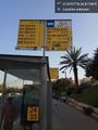
Tel Aviv bus station

Achievements