Difference between revisions of "2018-08-27 37 -87"
imported>Mystrsyko (Created page with "{{subst:Expedition |lat = 37 |lon = -87 |date = 2018-08-27 }}") |
imported>FippeBot m (Location) |
||
| (3 intermediate revisions by 2 users not shown) | |||
| Line 1: | Line 1: | ||
| − | |||
| − | |||
| − | |||
| − | |||
| − | |||
| − | |||
| − | |||
| − | |||
| − | |||
| − | |||
{{meetup graticule | {{meetup graticule | ||
| lat=37 | | lat=37 | ||
| Line 15: | Line 5: | ||
}} | }} | ||
| − | |||
__NOTOC__ | __NOTOC__ | ||
== Location == | == Location == | ||
| − | + | Just off Green River Rd in Evansville | |
== Participants == | == Participants == | ||
| − | + | [[User:Mystrsyko|Mystrsyko]] | |
| − | |||
== Plans == | == Plans == | ||
| − | + | Heading there on my bike now! | |
== Expedition == | == Expedition == | ||
| − | + | [[File:2018-08-27_37_-87_frown.jpg|260px|thumb|left|Stupid frown]] | |
| + | [[File:2018-08-27_37_-87_soybeans.jpg|260px|thumb|left|Location of the point]] | ||
| + | |||
| + | Rumors of my demise have been greatly exaggerated, for finally after nearly 3 years I have returned to the great sport of Geohashing. As they say, life...gets in the way. Quite a lot. Despite getting email alerts on my phone of nearby Geohashes every few days, they're always on days that I work or are otherwise inaccessible. Having the mighty Ohio River just south of home basically eliminates Kentucky as a geohashing possibility since the only crossing within 80 miles is an interstate highway. And the point a few weeks ago that was in the river itself didn't help either. | ||
| + | |||
| + | Anyway, today was my day off and my phone chirped with the brilliant news that the point of the day was just 3.5km away. That's almost walking distance! Expecting another completely unreachable point, I was extremely excited to find it was along my normal cycling route! Surly I couldn't pass up such a fine opportunity to Geohash once again. | ||
| + | |||
| + | I threw Collin the Hashfox in my pocket and set off on my bike to South Green River Road. Unfortunately, Evansville is not nearly as bike friendly as [[Springfield, Illinois]] was. I absolutely detest riding on Green River Road. It's super busy, narrow, and of course it's the only road that goes anywhere north or south in town. I couldn't even take side streets because some city planner back in the day thought it would be great if none of the neighborhoods connected to each other and instead everyone had to take high speed, high traffic, narrow roads to get anywhere. | ||
| + | |||
| + | I should stop ranting. Back to the geohash. | ||
| + | |||
| + | So I took my normal loop down near the river that ends up at the southern most point of Green River Road. I like to ride here because there's virtually zero traffic south of the interstate highway that runs along the levee. I jokingly call the floodplains here the "borderlands" because Interstate 69 is the border between this small cycling paradise and getting hit by a driver using their cell phone. | ||
| + | |||
| + | Riding up I was surprised to see tall, mature crops of corn on both sides of the road along the way. The floodplains here were under 10 feet of water back in the spring, and I kind of assumed the fields would not be very usable afterwards, but here I was presented with a mature soybean crop right where the hash point lay. | ||
| + | |||
| + | I got myself as close as I could along the side of the road, but the point lay nearly 200 feet further into the field, and was thus out of reach. There was no way I was stomping my way into a mature crop of soybeans. That's how you get yourself shot by the land owner. Alas, I was left with the somber task of taking the relevant photos of the area and one of my stupid <strike>grin</strike> frown, before heading up the Green River Road of Death on my way home. | ||
| + | |||
== Tracklog == | == Tracklog == | ||
| − | + | [https://www.strava.com/activities/1801004923 Strava] | |
== Photos == | == Photos == | ||
| Line 39: | Line 43: | ||
--> | --> | ||
<gallery perrow="5"> | <gallery perrow="5"> | ||
| + | Image:2018-08-27_37_-87collin.jpg|Collin is happy to be Geohashing again | ||
| + | Image:2018-08-27_37_-87_highway.jpg|The unofficial border of the borderlands | ||
| + | Image:2018-08-27_37_-87_road.jpg|This is midwestern America | ||
| + | Image:2018-08-27_37_-87_proof.png|The proof | ||
</gallery> | </gallery> | ||
== Achievements == | == Achievements == | ||
{{#vardefine:ribbonwidth|800px}} | {{#vardefine:ribbonwidth|800px}} | ||
| − | + | {{No trespassing | |
| − | |||
| − | |||
| − | |||
| − | |||
| − | + | | latitude = 37 | |
| + | | longitude = -87 | ||
| + | | date = 2018-08-27 | ||
| + | | name = Mystrsyko | ||
| + | | distance = 200 feet | ||
| − | + | }} | |
| − | |||
| − | |||
| − | |||
| − | |||
| − | |||
| − | |||
[[Category:Expeditions]] | [[Category:Expeditions]] | ||
| − | |||
[[Category:Expeditions with photos]] | [[Category:Expeditions with photos]] | ||
| − | |||
| − | |||
| − | |||
| − | |||
| − | |||
| − | |||
| − | |||
| − | |||
| − | |||
[[Category:Coordinates not reached]] | [[Category:Coordinates not reached]] | ||
| − | |||
| − | |||
| − | |||
| − | |||
| − | |||
[[Category:Not reached - No public access]] | [[Category:Not reached - No public access]] | ||
| − | + | {{location|US|IN|VA}} | |
| − | |||
| − | |||
| − | |||
| − | |||
| − | |||
| − | |||
| − | |||
Latest revision as of 04:00, 16 August 2019
| Mon 27 Aug 2018 in 37,-87: 37.9287957, -87.4922315 geohashing.info google osm bing/os kml crox |
Location
Just off Green River Rd in Evansville
Participants
Plans
Heading there on my bike now!
Expedition


Rumors of my demise have been greatly exaggerated, for finally after nearly 3 years I have returned to the great sport of Geohashing. As they say, life...gets in the way. Quite a lot. Despite getting email alerts on my phone of nearby Geohashes every few days, they're always on days that I work or are otherwise inaccessible. Having the mighty Ohio River just south of home basically eliminates Kentucky as a geohashing possibility since the only crossing within 80 miles is an interstate highway. And the point a few weeks ago that was in the river itself didn't help either.
Anyway, today was my day off and my phone chirped with the brilliant news that the point of the day was just 3.5km away. That's almost walking distance! Expecting another completely unreachable point, I was extremely excited to find it was along my normal cycling route! Surly I couldn't pass up such a fine opportunity to Geohash once again.
I threw Collin the Hashfox in my pocket and set off on my bike to South Green River Road. Unfortunately, Evansville is not nearly as bike friendly as Springfield, Illinois was. I absolutely detest riding on Green River Road. It's super busy, narrow, and of course it's the only road that goes anywhere north or south in town. I couldn't even take side streets because some city planner back in the day thought it would be great if none of the neighborhoods connected to each other and instead everyone had to take high speed, high traffic, narrow roads to get anywhere.
I should stop ranting. Back to the geohash.
So I took my normal loop down near the river that ends up at the southern most point of Green River Road. I like to ride here because there's virtually zero traffic south of the interstate highway that runs along the levee. I jokingly call the floodplains here the "borderlands" because Interstate 69 is the border between this small cycling paradise and getting hit by a driver using their cell phone.
Riding up I was surprised to see tall, mature crops of corn on both sides of the road along the way. The floodplains here were under 10 feet of water back in the spring, and I kind of assumed the fields would not be very usable afterwards, but here I was presented with a mature soybean crop right where the hash point lay.
I got myself as close as I could along the side of the road, but the point lay nearly 200 feet further into the field, and was thus out of reach. There was no way I was stomping my way into a mature crop of soybeans. That's how you get yourself shot by the land owner. Alas, I was left with the somber task of taking the relevant photos of the area and one of my stupid grin frown, before heading up the Green River Road of Death on my way home.
Tracklog
Photos
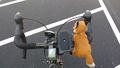
Collin is happy to be Geohashing again
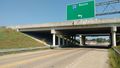
The unofficial border of the borderlands
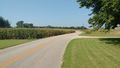
This is midwestern America
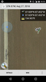
The proof


Achievements
Mystrsyko earned the No trespassing consolation prize
|