Difference between revisions of "2018-10-16 32 34"
From Geohashing
imported>Dubdub ([live picture]First stop: A bus station in Ramat Hasharon [http://www.openstreetmap.org/?lat=32.14683540&lon=34.83906950&zoom=16&layers=B000FTF @32.1468,34.8391]) |
imported>FippeBot m (Location) |
||
| (8 intermediate revisions by 4 users not shown) | |||
| Line 15: | Line 15: | ||
}} | }} | ||
| − | + | ||
__NOTOC__ | __NOTOC__ | ||
== Location == | == Location == | ||
| − | + | ||
The location where in Neve Amal, near Herzeliya, a major Israeli city. | The location where in Neve Amal, near Herzeliya, a major Israeli city. | ||
== Participants == | == Participants == | ||
| − | + | ||
| − | + | * [[User:Jordy|Jordy]], | |
| − | [[User:Jordy|Jordy]] | + | * [[User:Dubdub|Dubdub]] and |
| + | * a friend | ||
== Plans == | == Plans == | ||
<!-- what were the original plans --> | <!-- what were the original plans --> | ||
| + | |||
| + | Unknown | ||
== Expedition == | == Expedition == | ||
| Line 35: | Line 38: | ||
*This point fell near Herzeliya -- [[User:Dubdub|Dubdub]] ([[User talk:Dubdub|talk]]) 19:59, 16 October 2018 (GMT+03:00) | *This point fell near Herzeliya -- [[User:Dubdub|Dubdub]] ([[User talk:Dubdub|talk]]) 19:59, 16 October 2018 (GMT+03:00) | ||
| − | + | ||
| − | + | *After one bus ride, we are half a kilometer away -- [[User:Dubdub|Dubdub]] ([[User talk:Dubdub|talk]]) 20:41, 16 October 2018 (GMT+03:00) | |
| + | |||
| + | *The location happened to be inside a private house, so this is as close as we can get -- [[User:Dubdub|Dubdub]] ([[User talk:Dubdub|talk]]) 20:49, 16 October 2018 (GMT+03:00) | ||
| + | |||
| + | |||
== Photos == | == Photos == | ||
| − | + | ||
| − | + | ||
| − | |||
<gallery perrow="5"> | <gallery perrow="5"> | ||
Image:2018-10-16_32_34_Dubdub_1539710780669.jpg|First stop: A bus station in Ramat Hasharon [http://www.openstreetmap.org/?lat=32.14683540&lon=34.83906950&zoom=16&layers=B000FTF @32.1468,34.8391] | Image:2018-10-16_32_34_Dubdub_1539710780669.jpg|First stop: A bus station in Ramat Hasharon [http://www.openstreetmap.org/?lat=32.14683540&lon=34.83906950&zoom=16&layers=B000FTF @32.1468,34.8391] | ||
| + | Image:2018-10-16_32_34_Dubdub_1539711690001.jpg|We with the bus | ||
| + | Image:2018-10-16_32_34_Dubdub_1539711942405.jpg|We passed through a nice park | ||
| + | Image:2018-10-16_32_34_Dubdub_1539712200136.jpg|The house | ||
| + | |||
</gallery> | </gallery> | ||
| Line 51: | Line 61: | ||
<!-- Add any achievement ribbons you earned below, or remove this section --> | <!-- Add any achievement ribbons you earned below, or remove this section --> | ||
| − | + | * No Trespassing? | |
| − | |||
| − | |||
| − | |||
| − | |||
| − | |||
| − | |||
| − | |||
| − | |||
| − | |||
| − | |||
| − | |||
| − | |||
[[Category:Expeditions]] | [[Category:Expeditions]] | ||
| − | |||
[[Category:Expeditions with photos]] | [[Category:Expeditions with photos]] | ||
| − | |||
| − | |||
| − | |||
| − | |||
| − | |||
| − | |||
| + | [[Category:Not reached - No public access]] | ||
| + | [[Category:Coordinates not reached]] | ||
| − | |||
| − | |||
| − | |||
| − | |||
| − | |||
| − | |||
| − | |||
| − | |||
| − | |||
| − | |||
| − | |||
| − | |||
| − | |||
| + | <!-- or if ... :( | ||
| + | [[Category:Coordinates reached]] | ||
(Don't forget to delete this final close comment marker) --> | (Don't forget to delete this final close comment marker) --> | ||
| + | {{location|IL|TA}} | ||
Latest revision as of 12:36, 14 July 2019
| Tue 16 Oct 2018 in 32,34: 32.1675043, 34.8559224 geohashing.info google osm bing/os kml crox |
Location
The location where in Neve Amal, near Herzeliya, a major Israeli city.
Participants
Plans
Unknown
Expedition
- After one bus ride, we are half a kilometer away -- Dubdub (talk) 20:41, 16 October 2018 (GMT+03:00)
- The location happened to be inside a private house, so this is as close as we can get -- Dubdub (talk) 20:49, 16 October 2018 (GMT+03:00)
Photos
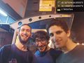
First stop: A bus station in Ramat Hasharon @32.1468,34.8391
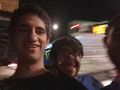
We with the bus

We passed through a nice park

The house


Achievements
- No Trespassing?