Difference between revisions of "2018-10-31 49 8"
imported>DODO (→Participants) |
imported>FippeBot m (Location) |
||
| (7 intermediate revisions by 2 users not shown) | |||
| Line 20: | Line 20: | ||
== Location == | == Location == | ||
<!-- where you've surveyed the hash to be --> | <!-- where you've surveyed the hash to be --> | ||
| − | In a forest | + | In a forest in Brühl just 600 m from my office. |
== Participants == | == Participants == | ||
| Line 29: | Line 29: | ||
== Plans == | == Plans == | ||
<!-- what were the original plans --> | <!-- what were the original plans --> | ||
| + | Well, too close to my office, for not going. Will walk there after work. | ||
== Expedition == | == Expedition == | ||
<!-- how it all turned out. your narrative goes here. --> | <!-- how it all turned out. your narrative goes here. --> | ||
| + | Seen from my office, the hash was behind a tennis-court. So I walked to the tennis-club and followed the fence around it. But then the fence got higher and was secured with barbed wire. It led me into a residential area and I had to walk in the opposite direction for a while. So I made a second approach from the west. But there was a high wall and a secured portal, and once again I had to walk away from the hash. At least I found a way to the Rheinauer See (lake) and walked along the lake. I came to the rear side of the tennis club, but in the direction of the hash there was a dense copse. I walked towards it but I found another wall, just 5 - 10 m into the copse. | ||
| + | |||
| + | The hash was obviously gated. So I gave up and walked back to my car at the office. | ||
== Tracklog == | == Tracklog == | ||
<!-- if your GPS device keeps a log, you may post a link here --> | <!-- if your GPS device keeps a log, you may post a link here --> | ||
| + | [https://www.komoot.de/tour/50905883 3,6 KM by foot] | ||
== Photos == | == Photos == | ||
| Line 40: | Line 45: | ||
Image:2012-##-## ## ## Alpha.jpg | Witty Comment | Image:2012-##-## ## ## Alpha.jpg | Witty Comment | ||
--> | --> | ||
| − | <gallery perrow=" | + | <gallery perrow="6"> |
| + | Image:2018-10-31_49_8-4.jpg|first approach: a fence | ||
| + | Image:2018-10-31_49_8-3.jpg|second approach: a wall | ||
| + | Image:2018-10-31_49_8-2.jpg|third approach: a copse and... | ||
| + | Image:2018-10-31_49_8_DODO_1541096974021.jpg|a wall, keeping me away from my goal | ||
| + | Image:2018-10-31_49_8-1.jpg|unhappy hasher | ||
| + | Image:2018-10-31_49_8-5.jpg|the best I got: 18m | ||
| − | |||
</gallery> | </gallery> | ||
| Line 48: | Line 58: | ||
{{#vardefine:ribbonwidth|800px}} | {{#vardefine:ribbonwidth|800px}} | ||
<!-- Add any achievement ribbons you earned below, or remove this section --> | <!-- Add any achievement ribbons you earned below, or remove this section --> | ||
| + | {{No trespassing | ||
| + | | latitude = 49 | ||
| + | | longitude = 8 | ||
| + | | date = 2018-10-31 | ||
| + | | name = DODO | ||
| + | | distance = 18m | ||
| − | + | }} | |
| − | |||
| − | |||
| − | |||
| − | |||
| − | |||
| − | |||
| − | |||
| − | |||
| − | |||
| − | |||
| − | |||
| − | |||
[[Category:Expeditions]] | [[Category:Expeditions]] | ||
| − | |||
| − | |||
| − | |||
| − | |||
| − | |||
| − | |||
| − | |||
| − | |||
| − | |||
| − | |||
| − | |||
[[Category:Coordinates not reached]] | [[Category:Coordinates not reached]] | ||
| − | |||
| − | |||
| − | |||
| − | |||
| − | |||
[[Category:Not reached - No public access]] | [[Category:Not reached - No public access]] | ||
| − | + | {{location|DE|BW|HD}} | |
| − | |||
| − | |||
| − | |||
| − | |||
| − | |||
| − | |||
| − | |||
Latest revision as of 04:13, 16 August 2019
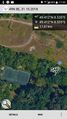
| Wed 31 Oct 2018 in 49,8: 49.4115949, 8.5352013 geohashing.info google osm bing/os kml crox |
Location
In a forest in Brühl just 600 m from my office.
Participants
Plans
Well, too close to my office, for not going. Will walk there after work.
Expedition
Seen from my office, the hash was behind a tennis-court. So I walked to the tennis-club and followed the fence around it. But then the fence got higher and was secured with barbed wire. It led me into a residential area and I had to walk in the opposite direction for a while. So I made a second approach from the west. But there was a high wall and a secured portal, and once again I had to walk away from the hash. At least I found a way to the Rheinauer See (lake) and walked along the lake. I came to the rear side of the tennis club, but in the direction of the hash there was a dense copse. I walked towards it but I found another wall, just 5 - 10 m into the copse.
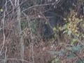
The hash was obviously gated. So I gave up and walked back to my car at the office.
Tracklog
Photos
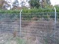
first approach: a fence
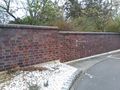
second approach: a wall
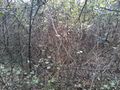
third approach: a copse and...
a wall, keeping me away from my goal

unhappy hasher
the best I got: 18m


Achievements
DODO earned the No trespassing consolation prize
|